
Mileage: 5.2 miles
Time: 3 hours
NH 4,000 footer: Mt. Tecumseh
--
Returning home to Boston on Friday night I was greeted with temperatures in the twenties and light snowfall, a stark contrast to the 85-degree sunny days I had enjoyed for a the 6 days prior while down in Florida with work. With Saturday's temperatures in the teens and relentless winds to boot, I laughed out loud when my good friend Rob (a long time member of the MA-based Jeep club I founded) sent me a text gauging my interest in hiking in the White Mountains on Sunday. Having not been in the mountains in almost exactly a month, I quickly jumped on the offer and agreed to meeting him the next morning halfway to the Waterville Valley trailhead for Mt. Tecumseh. The lowest of the 48 4,000-ft mountains that New Hampshire is home to, measuring in at 4,003 feet exactly, Tecumseh was an easily accessible trail and one that neither of us had hiked before. I packed up my equipment late Saturday night, triple checking the weather forecasts for the mountain and making gear decisions based on the predictions that temperatures would be falling well below zero once windchill was factored in.
Meeting just over the Mass/NH border at 08h00, we hopped in his Tacoma and made the rest of the hour journey north to the Waterville Valley ski mountain's parking lot, placed perfectly directly across a resort road from the trailhead we would start from. Donning the appropriate footwear and insulating layers for the single digit temperatures outside, we made our way across the road and began our trek around 09h30. The forest was nearly perfect, covered in a few inches of snow while the trail was clearly packed down by the plethora of hikers who had made their way up the same route in recent days. Weather in New England has been nothing shy of remarkable recently, especially given the season, and the condition of the ground reflected the warm temperatures that had swept the region. We made our way up the meandering terrain at a comfortable pace, conversing as we went about a plethora of miscellaneous things. Carefully analyzing rock placement, we made our way across a river before climbing up the other side and mutually deciding to stop and put on our microspikes light traction. While the snowfall in no way required snowshoes, I had mine strapped to my bag just in case they were going to be needed further up the mountain.
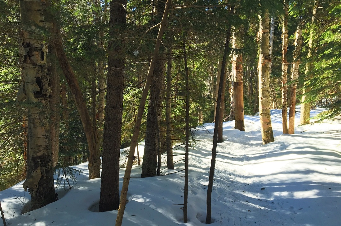
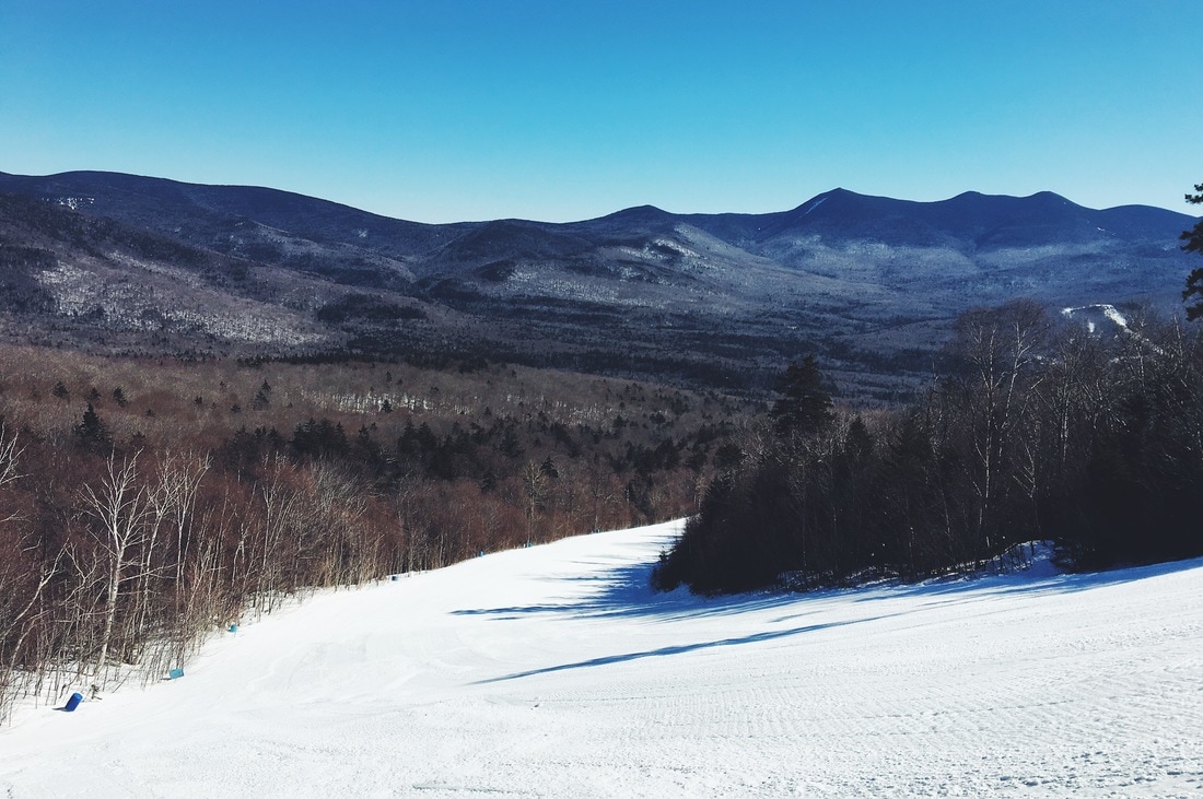
A few hundred feet after the river crossing we came about a short side trail to a Waterville ski slope, finding it completely void of anyone aside the two of us hikers. I'm not sure if the weather had turned people away, but I was a bit taken aback to see it empty on such a beautiful winter weekend. Turning back towards the trail we began the 1.3 mile climb to the summit of the mountain. Unlike many other climbs, the Tecumseh route was comprised of one long incline that was consistent and allowed us to gain the majority of our elevation. I led us up the mountain at Rob's request, and we took a handful of short breaks during the ascent to talk about projects and troubleshoot technical issues with Jeeps and electronics alike. Around 1100hrs I began seeing the saturated blue sky glowing behind distant trees instead of above them, a clear indication that we were nearing the top of whatever section of the mountain we were climbing. We progressed forwards, turning north and hiking across a gorgeously snow-covered ridge as the mid-morning sun cast shadows of barren trees across the forest floor. A few thousand feet further along we came across a fork in the trail, and a crooked sign offering each path as a route to the summit. A hiker we passed on the way up suggested the blue-blazed trail instead of the yellow-blazed, so we followed his suggestion, turning towards the west side of the mountain and carrying on.
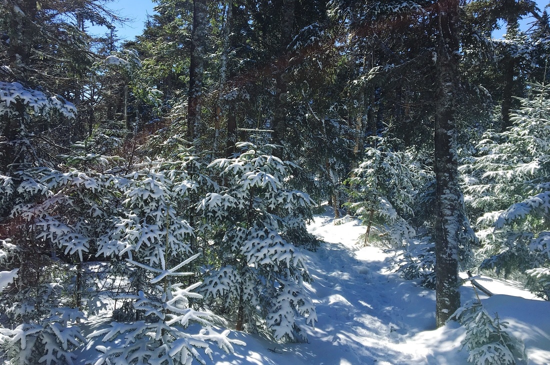
The trail climbed further as we walked a tight path towards the summit, taking in the gorgeous views of the mountain ranges to our left. It was along this section that I felt the wind becoming more prevalent, and stopped to put my Marmot shell back on, adding my microfiber face mask to my attire to try and protect myself from wind burn once we got further up. Making a sharp hairpin turn up the next leg of trail, we came to a flat area with a sign that I inferred as denoting the top of the mountain. With no ground higher than where we stood, I logically inferred that we had reached the top of Tecumseh, 4,003-feet above sea level, at just before 11h30. We snapped some photos and talked to another hiker who joined us as he measured the temperature with a far more advanced thermometer than the $4 one that I keep hooked to the side of my backpack. He informed us it was a whopping 4 degrees, and I was immediately glad to have added my extra layers before reaching the top. Rob didn't need to, as he sports a hell of a beard that kept his face warm. In looking at Waterville's temperature reports later last night I read their noon report of -10 degrees with windchill at their 3,400' peak, so I'm sure we were somewhere in the same range, if not a little lower.
We packed up and headed back down the mountain in short order, retracing our steps on the blue-blaze trail instead of bothering with the yellow route. I habitually adjusted my trekking poles to account for the descent, hoping to preemptively fight back against any knee pain I might feel the next day. Without running down the mountain per-say, we maintained a quick pace and covered the distance in half the time we took to ascend. Towards the bottom we came across a woman who had also summited while we were at the top, hiking along with her dog who wore a neon vest proclaiming "IGNORE ME". After introducing ourselves and a bit of conversation with Cynthia I correctly guessed that he was a shelter dog and had a real aversion to adult men. In a twist of irony, she knows my dad very well from hiking with him in the past, and was quick to ask how my parents were doing... I wasn't truly surprised by this as my dad is active in the New England hiking community, but it still made me laugh to be out in the woods and randomly meet someone who knew my parents.
Rob and I returned to the car shortly before 12h30, and stripped down our layers to something more comfortable for the two hour ride home. Three hours hiking and covering 5.2 miles was a great activity for a cold weekend day, and I'm exceptionally grateful he invited me to tag along. Out of curiosity I added up hikes after getting home, realizing I've climbed to 16 of the 48 four-thousand foot peaks in New Hampshire, a solid number for someone who hasn't actively been trying to check them off a list. In further conversation, Rob and I are going to try and make this more of a regular thing when I'm not traveling, which should be a nice way to get back in the woods more frequently than I'm usually able.
Hope you're all doing well. I've got another post to write about a photography trip a few weeks ago up to Mt. Washington, so keep an eye out for that in the coming days.
Onward & upward..
Tex
Time: 3 hours
NH 4,000 footer: Mt. Tecumseh
--
Returning home to Boston on Friday night I was greeted with temperatures in the twenties and light snowfall, a stark contrast to the 85-degree sunny days I had enjoyed for a the 6 days prior while down in Florida with work. With Saturday's temperatures in the teens and relentless winds to boot, I laughed out loud when my good friend Rob (a long time member of the MA-based Jeep club I founded) sent me a text gauging my interest in hiking in the White Mountains on Sunday. Having not been in the mountains in almost exactly a month, I quickly jumped on the offer and agreed to meeting him the next morning halfway to the Waterville Valley trailhead for Mt. Tecumseh. The lowest of the 48 4,000-ft mountains that New Hampshire is home to, measuring in at 4,003 feet exactly, Tecumseh was an easily accessible trail and one that neither of us had hiked before. I packed up my equipment late Saturday night, triple checking the weather forecasts for the mountain and making gear decisions based on the predictions that temperatures would be falling well below zero once windchill was factored in.
Meeting just over the Mass/NH border at 08h00, we hopped in his Tacoma and made the rest of the hour journey north to the Waterville Valley ski mountain's parking lot, placed perfectly directly across a resort road from the trailhead we would start from. Donning the appropriate footwear and insulating layers for the single digit temperatures outside, we made our way across the road and began our trek around 09h30. The forest was nearly perfect, covered in a few inches of snow while the trail was clearly packed down by the plethora of hikers who had made their way up the same route in recent days. Weather in New England has been nothing shy of remarkable recently, especially given the season, and the condition of the ground reflected the warm temperatures that had swept the region. We made our way up the meandering terrain at a comfortable pace, conversing as we went about a plethora of miscellaneous things. Carefully analyzing rock placement, we made our way across a river before climbing up the other side and mutually deciding to stop and put on our microspikes light traction. While the snowfall in no way required snowshoes, I had mine strapped to my bag just in case they were going to be needed further up the mountain.
A few hundred feet after the river crossing we came about a short side trail to a Waterville ski slope, finding it completely void of anyone aside the two of us hikers. I'm not sure if the weather had turned people away, but I was a bit taken aback to see it empty on such a beautiful winter weekend. Turning back towards the trail we began the 1.3 mile climb to the summit of the mountain. Unlike many other climbs, the Tecumseh route was comprised of one long incline that was consistent and allowed us to gain the majority of our elevation. I led us up the mountain at Rob's request, and we took a handful of short breaks during the ascent to talk about projects and troubleshoot technical issues with Jeeps and electronics alike. Around 1100hrs I began seeing the saturated blue sky glowing behind distant trees instead of above them, a clear indication that we were nearing the top of whatever section of the mountain we were climbing. We progressed forwards, turning north and hiking across a gorgeously snow-covered ridge as the mid-morning sun cast shadows of barren trees across the forest floor. A few thousand feet further along we came across a fork in the trail, and a crooked sign offering each path as a route to the summit. A hiker we passed on the way up suggested the blue-blazed trail instead of the yellow-blazed, so we followed his suggestion, turning towards the west side of the mountain and carrying on.
The trail climbed further as we walked a tight path towards the summit, taking in the gorgeous views of the mountain ranges to our left. It was along this section that I felt the wind becoming more prevalent, and stopped to put my Marmot shell back on, adding my microfiber face mask to my attire to try and protect myself from wind burn once we got further up. Making a sharp hairpin turn up the next leg of trail, we came to a flat area with a sign that I inferred as denoting the top of the mountain. With no ground higher than where we stood, I logically inferred that we had reached the top of Tecumseh, 4,003-feet above sea level, at just before 11h30. We snapped some photos and talked to another hiker who joined us as he measured the temperature with a far more advanced thermometer than the $4 one that I keep hooked to the side of my backpack. He informed us it was a whopping 4 degrees, and I was immediately glad to have added my extra layers before reaching the top. Rob didn't need to, as he sports a hell of a beard that kept his face warm. In looking at Waterville's temperature reports later last night I read their noon report of -10 degrees with windchill at their 3,400' peak, so I'm sure we were somewhere in the same range, if not a little lower.
We packed up and headed back down the mountain in short order, retracing our steps on the blue-blaze trail instead of bothering with the yellow route. I habitually adjusted my trekking poles to account for the descent, hoping to preemptively fight back against any knee pain I might feel the next day. Without running down the mountain per-say, we maintained a quick pace and covered the distance in half the time we took to ascend. Towards the bottom we came across a woman who had also summited while we were at the top, hiking along with her dog who wore a neon vest proclaiming "IGNORE ME". After introducing ourselves and a bit of conversation with Cynthia I correctly guessed that he was a shelter dog and had a real aversion to adult men. In a twist of irony, she knows my dad very well from hiking with him in the past, and was quick to ask how my parents were doing... I wasn't truly surprised by this as my dad is active in the New England hiking community, but it still made me laugh to be out in the woods and randomly meet someone who knew my parents.
Rob and I returned to the car shortly before 12h30, and stripped down our layers to something more comfortable for the two hour ride home. Three hours hiking and covering 5.2 miles was a great activity for a cold weekend day, and I'm exceptionally grateful he invited me to tag along. Out of curiosity I added up hikes after getting home, realizing I've climbed to 16 of the 48 four-thousand foot peaks in New Hampshire, a solid number for someone who hasn't actively been trying to check them off a list. In further conversation, Rob and I are going to try and make this more of a regular thing when I'm not traveling, which should be a nice way to get back in the woods more frequently than I'm usually able.
Hope you're all doing well. I've got another post to write about a photography trip a few weeks ago up to Mt. Washington, so keep an eye out for that in the coming days.
Onward & upward..
Tex
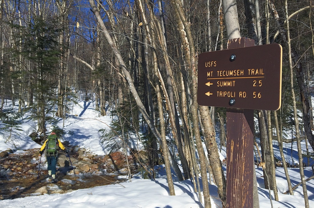
Parking Lot Trailhead
Sunshine & Shadows
Waterville Valley's "Lower Periphery" Slope
Blue Skies towards the Summit
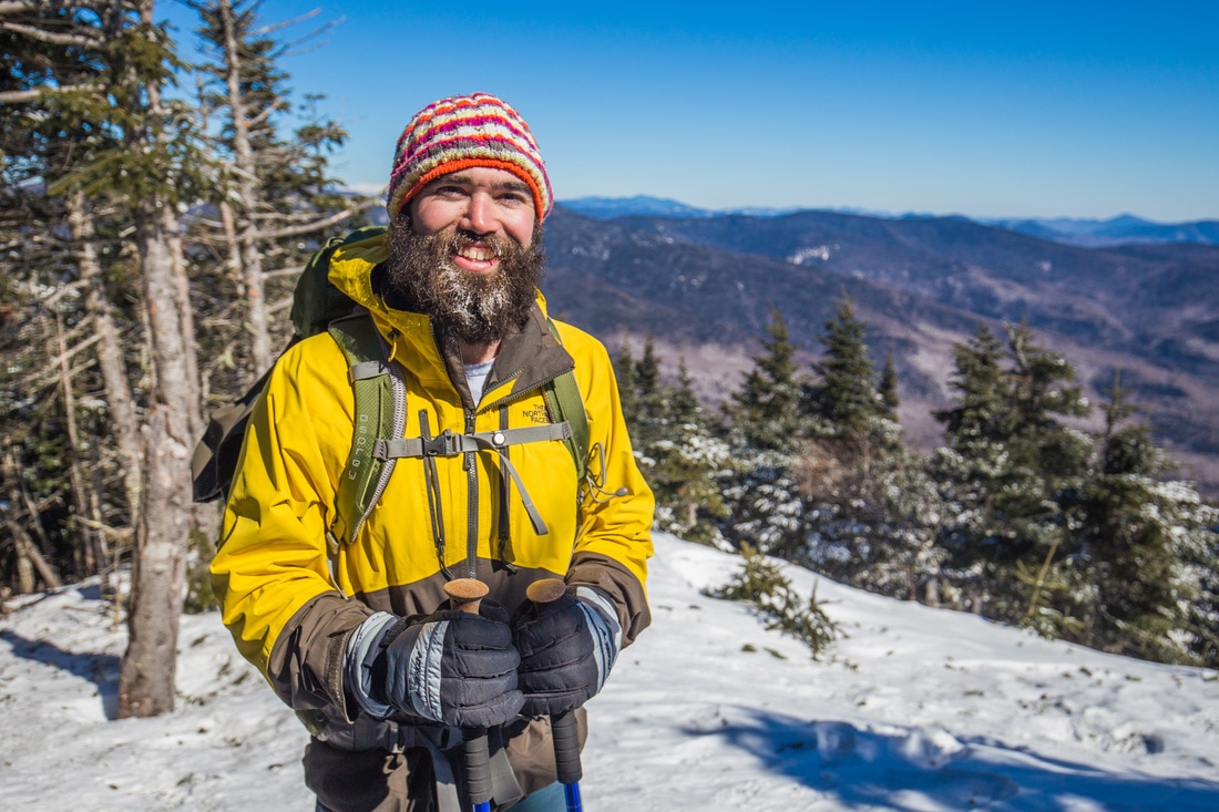
Rob and the impressive icicle-beard.
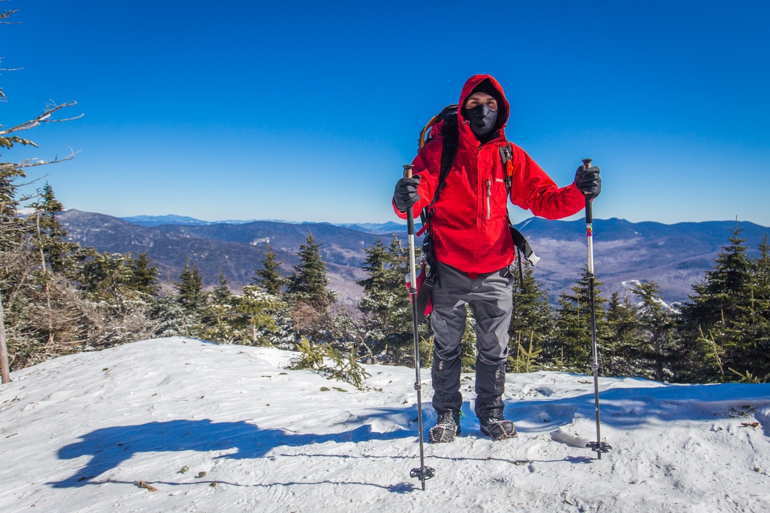
I'm obviously dressed for the occasion.


 RSS Feed
