
Trail: Old Rag Mountain - Shenandoah National Park, VA
Distance: 9.1 miles
Time: 4 hours
After a few days on the Gulf Coast of Florida for work I flew up to Washington D.C. for another event. Due to a miscommunication regarding the schedule, my flight home left me with a 36 hour window to explore the region however I wanted. While touring the National Mall (something I've done before) was obviously an option, a friend and I decided that exploring Shenandoah National Park was an infinitely better use of time. It is with great pleasure that I write today's post featuring a once-pivitol and popular character of this blog: my friend Pneumo. A resident of northern Virginia, he was able to travel about twenty minutes from home to get me from the Gaylord National hotel along the Potomac. We returned to his house to drop off my bags, picked up a breakfast burrito from a local restaurant, and began the two hour drive southwest towards Shenandoah National Park. As we hopped up on the highway we debated what we'd be hiking, whether or not we wanted to revisit the Appalachian Trail or find another route to undertake. Seeing as I had just spent over a hundred miles on the Trail itself I wasn't thrilled at the idea of hiking on it again just yet, at which point he suggested a favorite hike about 20 miles from the park's famous Skyline Drive entrance. We'd be undertaking Old Rag Mountain, a 9.1 mile loop over a jagged and rocky summit with just under 2,500' of elevation gain. In my research since returning from the trail I've learned it is the 2nd most popular hike in the Shenandoahs per TripAdvisor.com, and the National Park Service calls it their "most popular and dangerous" attraction in the park… interesting, but understandable!
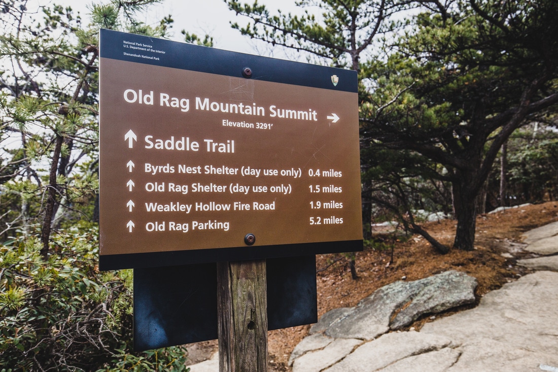
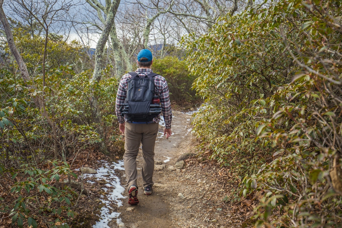
Parking in the lower lot at the end of a sleepy Virginia backroad we deposited the nominal Forestry Service parking fee before beginning our trek up the paved road to where the trail actually began. It honestly must have been quite the comical sight, the two of us moving along. Since I packed for Florida weather and work, my most appropriate outfit for this was a pair of jeans, New Balance polyester top, and my typical NB trail runners. We each sported a black backpack, but moved along with the pace of people who have done a fair bit of hiking. Upon reaching the upper parking lot, chained off for the winter, we turned sharply left onto a wide dirt trail that began our ascent up the mountain. It was such a shock to be on a wide and easily discernible trail, a stark comparison to the hours of difficult navigation I had recently spent on the A.T. up in Vermont. Pneumo admitted he hadn't done a lot of hiking recently, and his breathing got heavier as he followed me up the mountain. With occasional and gentle switchbacks, we watched the valley floor drop below us as trees became even more sparse and the terrain more steeply sloped. As we made our way further to the top the north side of the trail we were hiking became covered with snow that hadn't yet seen sunlight or temperatures that would have allowed it to melt. Stopping for a quick break at a false summit, our first open vista, we snapped some photos before continuing upwards towards the 3,284-foot peak. The terrain became much different after that first overlook, turning to massive boulders that required hand-over-hand climbing to get up and over. Some of these rocks, measuring nearly thirty feet tall, appeared to have once split apart from each other creating narrow gaps through which the trail traversed. This part was fantastically fun, reminding me of the scramble up Maine's Katahdin, and at some points required squeezing my backpack ahead of myself in order to shimmy through the crevices. We climbed up and out of one boulder formation to be greeted with a mixture of barely discernable light snow and rain, a product of the windy and low-40s weather outside. Clouds flew overhead as we walked over the top of more rocks, descending into the trees for a hundred feet or so before we came across a lone signpost proclaiming distances to the summit, the rock scramble, and the parking lot where we came from.
We took the short side trail to Old Rag Mountain's true summit, climbing up the highest boulder, quickly observing our surroundings before hopping back down and more thoroughly analyzing the sign to see what distance lay between us and the car. A quick snack was provided courtesy of the Delta airlines biscoff cookies I keep in my backpack before we glanced at our watches and began descending the mountain. At this point it was 1430hrs, not at all bad for a two hour, 4.8 mile trek from where we began. The trail itself is a loop of sorts, with just over 5 miles of trail remaining until we got back to the car. The opposite side of the mountain where the route took us was exposed to much more sunlight than the face we ascended, and the dirt was more of a thick mud than anything else. Slipping a bit here and there we continued downward at a great pace, though missing each joking about how our knees would hurt the next day. Halfway down the mountain's moderate descent we came across the Byrd's Nest Shelter, a stone building designed as a day-use facility for hikers in the summer, though it was closed up and locked for the winter months. It was shortly after passing the shelter that we came across the first people we'd seen since leaving the parking lot, a young couple also making their way down the mountain. Pneumo and I carried on our conversation, and they took notice of the fact that we were behind them… I guess we're used to a bit more courteous hiking, because after a few minutes it was Pneumo that spoke up to ask if we could pass them. No issues, they immediately stepped aside and we moved along down the trail. Passing one more couple in the next half-mile stretch, we eventually made it down to the Forest Service road that wraps its way up the side of the mountain. Turning east, we walked at a comfortable pace down the wide dirt road back towards the trailhead.
Making a brief stop to photograph a few waterfalls before reaching the car, we pulled into the parking lot around 1630hrs. To our astonishment, Pneumo's red Subaru had been joined by a large, colorfully unique motor vehicle… none other than the Oscar Meyer Wienermobile. I have zero idea as to why this thing was parked in a dirt lot at the end of a backcountry road in the hillsides of western Virginia, but alas there it was. We snapped some photos of it before packing up in our own car and heading back towards the highway. I asked that we stop so I could get a few photos of some fascinating cloud formations behind a barn and rolling terrain on our way back, which my friend gladly accommodated. A chicken-parm dinner at an Italian restaurant local to him served as our dinner after the 9+ mile hike, and we enjoyed a beer by a fire in his family's backyard before crashing for the night.
I flew back to Boston this morning and will have a few days here before heading out again. It was fantastic to see my friend and to hike with him for the first time since we parted ways shortly before the New York state line on the Appalachian Trail almost 2 and a half years ago. We've made some plans to meet up this summer and hopefully do some more hiking, which I'll very much look forward to. In the mean time, I'll just have to find mini-adventures wherever I can.
Onward & upward,
Texaco
Distance: 9.1 miles
Time: 4 hours
After a few days on the Gulf Coast of Florida for work I flew up to Washington D.C. for another event. Due to a miscommunication regarding the schedule, my flight home left me with a 36 hour window to explore the region however I wanted. While touring the National Mall (something I've done before) was obviously an option, a friend and I decided that exploring Shenandoah National Park was an infinitely better use of time. It is with great pleasure that I write today's post featuring a once-pivitol and popular character of this blog: my friend Pneumo. A resident of northern Virginia, he was able to travel about twenty minutes from home to get me from the Gaylord National hotel along the Potomac. We returned to his house to drop off my bags, picked up a breakfast burrito from a local restaurant, and began the two hour drive southwest towards Shenandoah National Park. As we hopped up on the highway we debated what we'd be hiking, whether or not we wanted to revisit the Appalachian Trail or find another route to undertake. Seeing as I had just spent over a hundred miles on the Trail itself I wasn't thrilled at the idea of hiking on it again just yet, at which point he suggested a favorite hike about 20 miles from the park's famous Skyline Drive entrance. We'd be undertaking Old Rag Mountain, a 9.1 mile loop over a jagged and rocky summit with just under 2,500' of elevation gain. In my research since returning from the trail I've learned it is the 2nd most popular hike in the Shenandoahs per TripAdvisor.com, and the National Park Service calls it their "most popular and dangerous" attraction in the park… interesting, but understandable!
Parking in the lower lot at the end of a sleepy Virginia backroad we deposited the nominal Forestry Service parking fee before beginning our trek up the paved road to where the trail actually began. It honestly must have been quite the comical sight, the two of us moving along. Since I packed for Florida weather and work, my most appropriate outfit for this was a pair of jeans, New Balance polyester top, and my typical NB trail runners. We each sported a black backpack, but moved along with the pace of people who have done a fair bit of hiking. Upon reaching the upper parking lot, chained off for the winter, we turned sharply left onto a wide dirt trail that began our ascent up the mountain. It was such a shock to be on a wide and easily discernible trail, a stark comparison to the hours of difficult navigation I had recently spent on the A.T. up in Vermont. Pneumo admitted he hadn't done a lot of hiking recently, and his breathing got heavier as he followed me up the mountain. With occasional and gentle switchbacks, we watched the valley floor drop below us as trees became even more sparse and the terrain more steeply sloped. As we made our way further to the top the north side of the trail we were hiking became covered with snow that hadn't yet seen sunlight or temperatures that would have allowed it to melt. Stopping for a quick break at a false summit, our first open vista, we snapped some photos before continuing upwards towards the 3,284-foot peak. The terrain became much different after that first overlook, turning to massive boulders that required hand-over-hand climbing to get up and over. Some of these rocks, measuring nearly thirty feet tall, appeared to have once split apart from each other creating narrow gaps through which the trail traversed. This part was fantastically fun, reminding me of the scramble up Maine's Katahdin, and at some points required squeezing my backpack ahead of myself in order to shimmy through the crevices. We climbed up and out of one boulder formation to be greeted with a mixture of barely discernable light snow and rain, a product of the windy and low-40s weather outside. Clouds flew overhead as we walked over the top of more rocks, descending into the trees for a hundred feet or so before we came across a lone signpost proclaiming distances to the summit, the rock scramble, and the parking lot where we came from.
We took the short side trail to Old Rag Mountain's true summit, climbing up the highest boulder, quickly observing our surroundings before hopping back down and more thoroughly analyzing the sign to see what distance lay between us and the car. A quick snack was provided courtesy of the Delta airlines biscoff cookies I keep in my backpack before we glanced at our watches and began descending the mountain. At this point it was 1430hrs, not at all bad for a two hour, 4.8 mile trek from where we began. The trail itself is a loop of sorts, with just over 5 miles of trail remaining until we got back to the car. The opposite side of the mountain where the route took us was exposed to much more sunlight than the face we ascended, and the dirt was more of a thick mud than anything else. Slipping a bit here and there we continued downward at a great pace, though missing each joking about how our knees would hurt the next day. Halfway down the mountain's moderate descent we came across the Byrd's Nest Shelter, a stone building designed as a day-use facility for hikers in the summer, though it was closed up and locked for the winter months. It was shortly after passing the shelter that we came across the first people we'd seen since leaving the parking lot, a young couple also making their way down the mountain. Pneumo and I carried on our conversation, and they took notice of the fact that we were behind them… I guess we're used to a bit more courteous hiking, because after a few minutes it was Pneumo that spoke up to ask if we could pass them. No issues, they immediately stepped aside and we moved along down the trail. Passing one more couple in the next half-mile stretch, we eventually made it down to the Forest Service road that wraps its way up the side of the mountain. Turning east, we walked at a comfortable pace down the wide dirt road back towards the trailhead.
Making a brief stop to photograph a few waterfalls before reaching the car, we pulled into the parking lot around 1630hrs. To our astonishment, Pneumo's red Subaru had been joined by a large, colorfully unique motor vehicle… none other than the Oscar Meyer Wienermobile. I have zero idea as to why this thing was parked in a dirt lot at the end of a backcountry road in the hillsides of western Virginia, but alas there it was. We snapped some photos of it before packing up in our own car and heading back towards the highway. I asked that we stop so I could get a few photos of some fascinating cloud formations behind a barn and rolling terrain on our way back, which my friend gladly accommodated. A chicken-parm dinner at an Italian restaurant local to him served as our dinner after the 9+ mile hike, and we enjoyed a beer by a fire in his family's backyard before crashing for the night.
I flew back to Boston this morning and will have a few days here before heading out again. It was fantastic to see my friend and to hike with him for the first time since we parted ways shortly before the New York state line on the Appalachian Trail almost 2 and a half years ago. We've made some plans to meet up this summer and hopefully do some more hiking, which I'll very much look forward to. In the mean time, I'll just have to find mini-adventures wherever I can.
Onward & upward,
Texaco
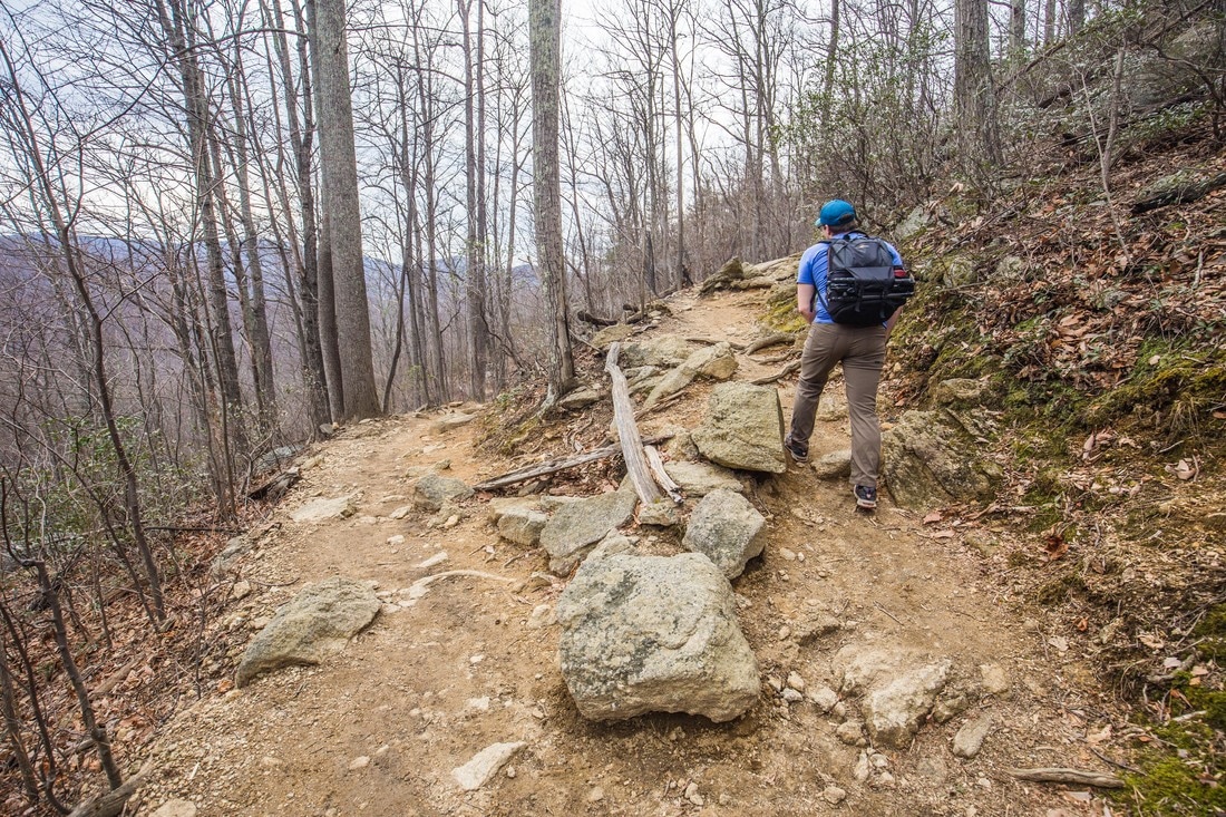
Climbing the Switchbacks
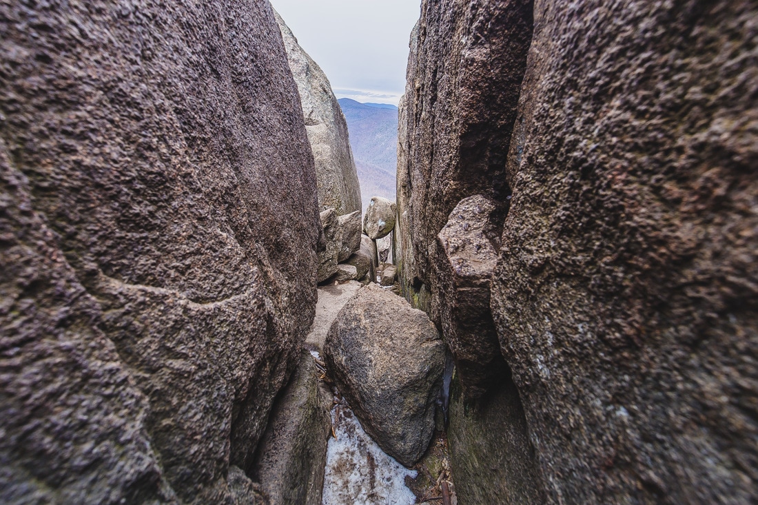
This is the trail, with about 18" between the rocks.
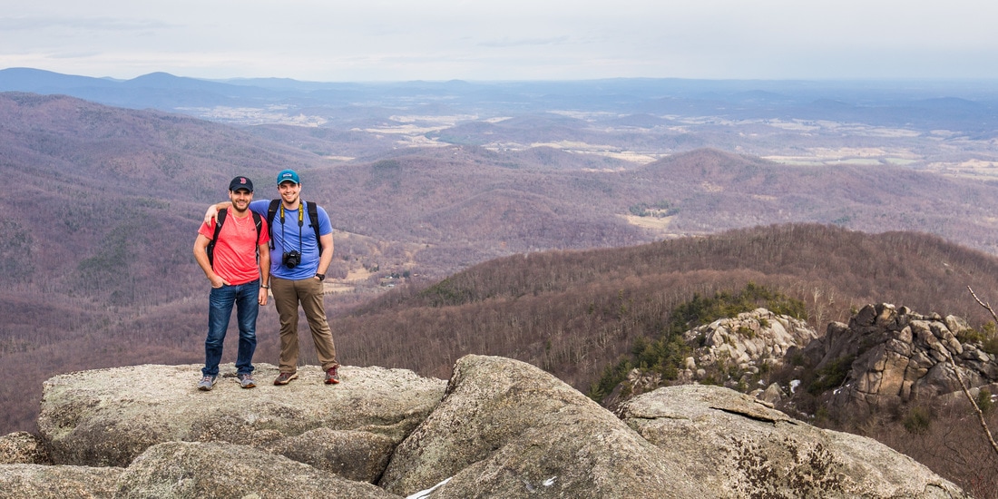
Old Rag Summit - 3,284 feet
Descending the southern face
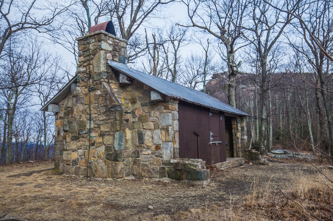
Byrd's Nest Shelter
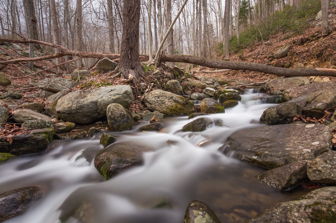
Brokenback Run River
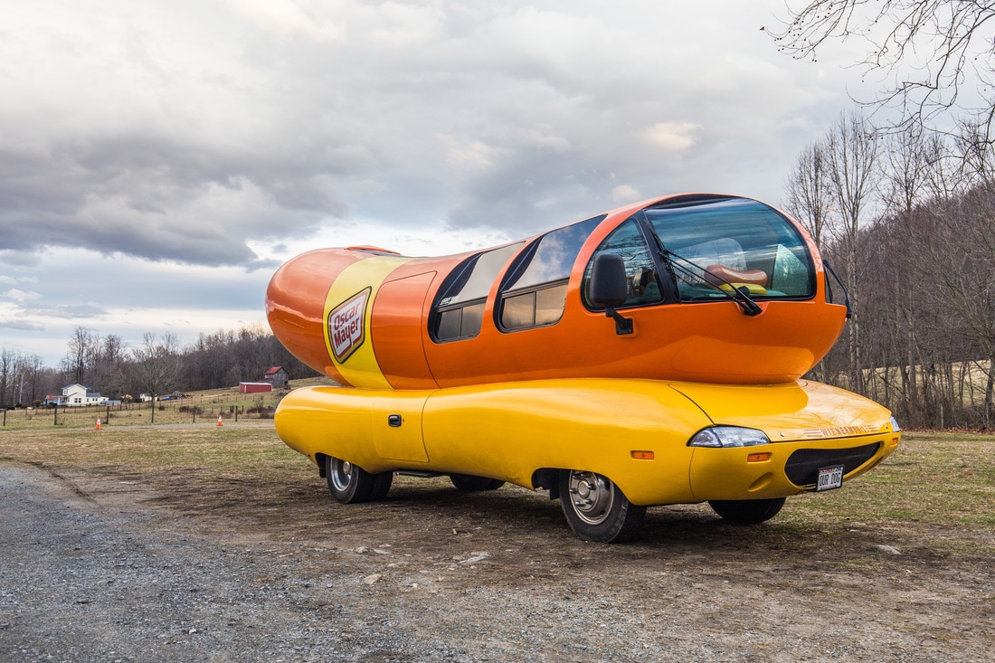
The exceptionally random Oscar Meyer Wienermobile
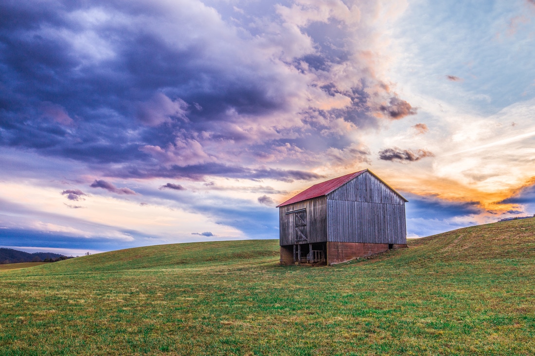
Countryside Sunset - Sperryville, Virginia


 RSS Feed
