2180miles
  • Home
  • Adventure Blog
  • Overland
    • Meet The Jeep
    • Mods & Installs
    • Overland Gear
    • Trip Reports & Videos >
      • Allagash Winter 2019
      • Greece Adventures 2019
      • Overland Expo East 2018
      • Allagash Wilderness 2018
      • Trans-Canada Overland 2017
      • QB-5 Adventure 2017
  • Long Trail
    • Trip Summary
    • Photojournal
    • Hike Statistics
  • Appalachian Trail
    • Trip Summary
    • Photojournal
    • Gear Talk
    • Hike Statistics
    • Financial Planning
  • Bicycling America
    • Trip Summary
    • Photojournal

Calgary, Alberta

11/16/2017

0 Comments

 
My fall has been crazy with travel, so you'll have to forgive the delay in posting here. I promise I'll wrap this adventure up before the end of the year.

If you will, travel through time with me back to mid-August...

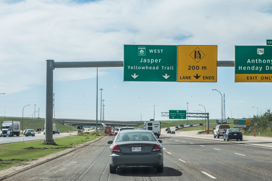
Our itinerary had us spending two nights in Calgary, with our actual tourist day slated for that Saturday. We woke up with the sun, partially due to habit of the past weeks of living in a tent, but more likely due to the floor to ceiling glass windows that our Airbnb was outfitted with flooding the room with light. While Dani showered I got our massive pile of laundry together, breaking it up into separate loads to fit inside the tiny washer and dryer we had in the unit. Once the first load was in and we looked presentable to the world, we wandered out the door and into the local urban neighborhood that surrounded the apartment building. Our first priority was to get caffeine in a cup for my girlfriend, at which point she became much more enthusiastic about the day. We found a really unique corner shop called Analog Coffee, a small establishment with white walls lined with vinyl records on shelves, mismatched photos, and a lively atmosphere created by the long lines of a younger crowd.
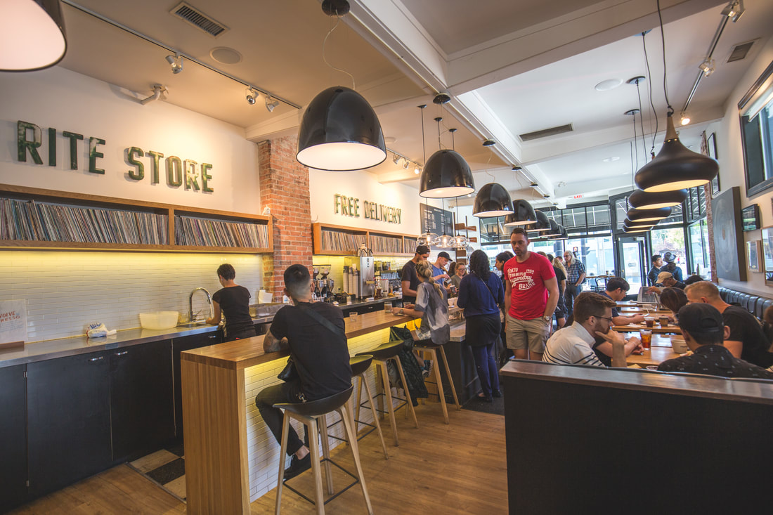
​
Picture
Analog Coffee Shop
Picture
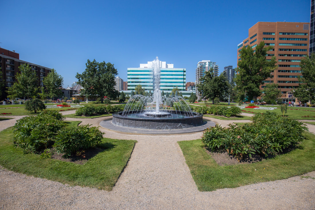
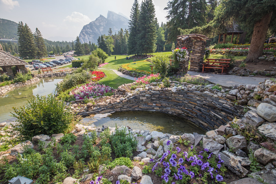
The Central Memorial Garden

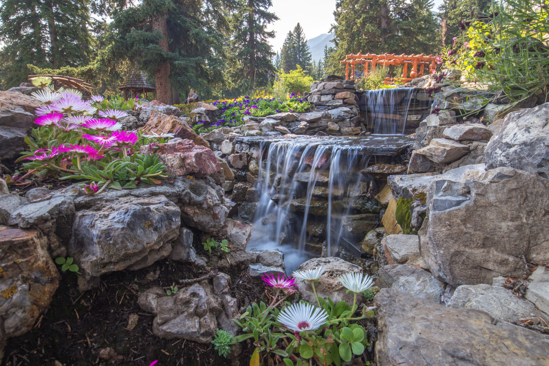
Once coffee was in hand, Dani and I began the search for a late breakfast/early lunch. As it turns out, Calgary is not the most gluten-aware city, and we struggled to find a place that could tailor to our dietary needs… making the most of it, we turned our search into a bit of an adventure, wandering the streets going restaurant to restaurant looking for a place to eat. I spoke to my parents on the phone as Dani eventually turned to Google searches, and updated them on our whereabouts and upcoming plans. By the time I got off the phone we had found a destination for lunch and began our walk a few blocks to get there. Passing through Calgary’s Central Memorial Garden, we enjoyed the symmetry and beauty of the fountains, pathways, and flowerbeds. On the opposite side of the small park I noticed a restaurant called The Beltliner, a diner-style venue with bright red lettering that looked like a modern take on a decades past establishment. We checked out the menu, delighted to find a gluten free bun for sandwiches, and quickly decided to scrap our initial plans and eat at The Beltliner instead. With the clock moving closer to noon we thought it appropriate to enjoy a local hard cider called Broken Ladder and perused the menu, ultimately deciding on a large bowl of tomato soup and each our own entrée, hers a sandwich of some sort while I went with chicken and waffles.
​

Early on in the trip we stumbled across the tidbit of information that Dani had never read (or been read) Goodnight Moon, and ironically enough the restaurant had a copy for kids to read while waiting for their meals. As we sipped our ciders and ate the incredibly delicious soup I read her the book aloud, showing the illustrations in a form that any kindergarten teacher would be proud of. After lunch we strolled back ten blocks or so to our apartment, soaking up the sunlight and truly just enjoying our last day together. More laundry was done throughout the afternoon as I took occasional trips down to the Jeep to re-pack our gear in a more solo-friendly way for the long (2,700+ mile) drive home. Our next morning wouldn’t be an early start, but likely a hectic one as we made our way to YYC -  Calgary International Airport - for her 13h00 departure back to Orlando. Early in the evening a little more time spent on Google found us an entirely gluten friendly restaurant a few minutes walk from the apartment where we got our meals as take out, returning to the couch and concluding our evening with a screening of Disney/Pixar’s UP!, a movie she had never seen. It was exceptionally nice to relax and watch the animated film as we ate dinner and the sun disappeared over the horizon outside, the night moving in and darkness settling over the city around us.

The idea that the trip was coming even closer to its end was weighing on my heart and spirits, but I fell asleep that night remembering the past three weeks, smiling at the thought of how lucky we were, all the things we had done, and all that we had seen.


Picture
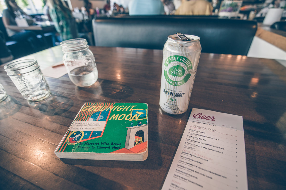
Vibes at The Beltliner
Picture
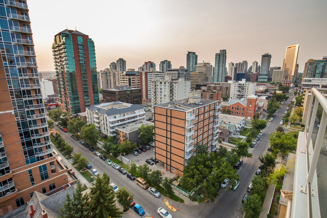
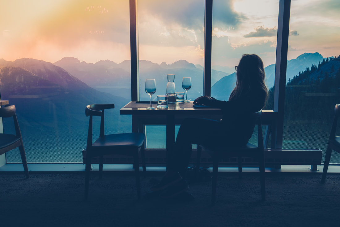
Golden Hour from our Airbnb
0 Comments

Tea Hut Hike & City Lights

10/12/2017

2 Comments

 
The beauty of the stars glistening in the sky overhead was slightly interrupted throughout the night by trucks passing on the nearby highway. We woke with the sun, the air cooler and more crisp than on other mornings, and I began packing up camp immediately as Dani prepared us a quick breakfast. We had one mission: make it to the Lake Louise parking lot before the masses of other visitors arrived; the focus of our day was entirely on a Pinterest-worthy “Tea Hut Hike”. Due to my incredible campsite finding skills the drive to Louise took no more than five minutes, and we arrived early enough to secure a parking lot just a few cars from the trailhead entrance. We packed my 66L Cold Cold World bag with the appropriate gear we’d need for a day hike, and though the bag itself probably appeared to be overkill to anyone walking by us, it served us well. I included a light windbreaker for myself, my camera bag with a few lenses, an extra liter of water for us to share when our primary ones ran dry, and the usual bag of minor medical supplies and a headlamp just in case. The snowshoe straps on the exterior of the bag worked phenomenally as a place to fasten my aluminum tripod to, and there was plenty of space left in the backpack to fill with Dani’s extra layers as the day got warmer. We made a final restroom stop in the gorgeous Lake Louise Fairmont hotel and made our way to the trailhead alongside the lake’s shore as hundreds of people gathered to take photos of the water as we had a few days prior.
Picture
Lake Louise Wild Campsite
Picture
Dressed For A Different Season!
Picture
Carved Out Switchbacks

The Lake Agnes Tea House hike is a notable attraction for people of all ages and abilities visiting the Lake Louise area. Climbing from the water’s edge up into the mountains the trail covers 3.4km each way and gains just over 1,100-feet of elevation as it goes along. The trail is relatively well manicured throughout the hike, and is four people wide for the most part. Temperatures were in the high 60s as we started our trek and we looked funny standing next to each other, me in a short sleeved polyester New Balance top and shorts, Dani in a hooded down jacket, fleece insulating layer, and long sleeve polyester top with yoga pants. One of the exciting things for me on this day was the opportunity to test out a new pair of active-wear compression shorts called Eletrunks (more on that later). I took the lead as we passed the trailhead sign and carried on happily at my usual 3 mph pace for a few hundred feet before realizing that it wasn’t a pace we would be able to happily maintain. I urged Dani to hike in front of me so that I could match her pace, and we carried on that way for the next two hours.
 
The trail wove its way through a pine tree forest, carving switchbacks into the side of the mountain as we climbed to the Lake Agnes Tea Hut. It was awesome to see all the people out hiking, as there was absolutely no blatantly noticeable demographic of the people around us. For the most part the hikers were Asian, and we very rarely heard English spoken as we moved along, passing most people and occasionally being passed by others. Some people on the trail wore what I would consider normal hiking clothes, polyester or wool, while others wore anything from jeans to khakis to long dresses, t-shirts, pea-coats, denim jackets (with glittery bedazzles), any anything in between. Footwear ranged from trail runners to over-the-ankle leather hiking boots, flip-flops to heels, and one person trekking barefoot. There were a handful of backpacks and a few Coach/Michael Kors bags, with the majority of people simply carrying a bottle of water in their hands. I’m sure my backpack looked like overkill to many.
 
As we climbed higher the trees occasionally gave way for unobstructed views to the saturated water of Lake Louise below us and the snow-capped peaks on the ridges opposite us. We stopped for a quick snack, water, and rest break just over halfway up and sat on a fallen tree that was well positioned for sitting on. From there the trail became more strewn with rocks bulging out of the dirt as the sun reached the perfect height to be baking down on our backs. At one point we passed a corral of horses tied up and being groomed by a mountain guide, evidence of the tour company that brings people up to the tea hut on horseback for the small fee of $180 or so. We learned (thanks to an inquisitive guy in front of us) that this was the highest point the horses get to, leaving the paying client to hike the last quarter mile to the tea hut itself.  A bit further up the trail we made a sharp hairpin turn by a waterfall, run-off from Lake Agnes, then began climbing a steep set of grated steel stairs that brought us up alongside the side foundation of the tea hut itself. The large wooden building sits nicely up on the edge of Lake Agnes, only a dozen feet from the steep rock cliff that the stairs parallel, and the large patio was buzzing with noise from the immeasurable number of hikers who were waiting to order tea or snacks. With an unknown wait time to actually sit on the porch, we got a cup of tea and a cookie from the “To-Go” line and went to sit on a rock by the edge of the lake and soak up the sun and scenery of this gorgeous summer day.
Picture
Picture
Mt. Niblock
Picture
Lake Agnes Tea Hut
Picture
Exploring Rock Fields
Picture
Lake Agnes
After finishing our tea and snack we cautiously stepped out onto the expansive rocky shore of the eastern side of the lake, cooling off in the shadows of the mountain peaks above us. Taking some goofy photos with my camera, the snow on the other side of the emerald green lake caught Dani’s attention, and we changed our itinerary to include a venture to the snow pack on the southern edge of Lake Agnes. It was fun to explore the mountain, making our way up a rocky avalanche chute, seeing different kinds of vegetation and wildlife from anywhere else in the park. The terrain was toying with my mind as I began daydreaming about a thru-hike of the Pacific Crest or Continental Divide Trails. Around high noon we turned back towards the tea hut and waiting in the excruciatingly long line for their privy-style restrooms before beginning our descent of the mountain. Dani led the way again, enjoying the ease of the down-hill slope and passing almost everyone in front of us as we went along. I was genuinely happy to see so many people out in the mountains for the day, and made repeated comments to Dani about how great it was to see people challenging themselves  - I say this kindly, many people appeared to be challenging themselves with the hike – and experiencing the national park in more fulfilling way than tourism from a car window could ever provide. We arrived back at the picturesque shore of Lake Louise at 13h00 having hiked just under 7 miles to, from, and around Lake Agnes.
 
Gentlemen readers: revisiting the mentioning of Eletrunks from earlier in the post, I wanted to take a second to talk about them in more detail. A week before the start of our trip I was contacted by one of the co-founders of this Brooklyn, NY company about testing out their compression shorts during my adventures. Over my years backpacking, cycling, running, even doing generic outdoor sweaty activities, I have tested many different manufacturer’s compression shorts. The design of Eletrunks allows for some “compartmentalization” that immensely improves discomfort and almost all potential for chaffing. Few companies, if any, address this as attentively and elegantly as Eletrunks does. I can confidently say that I’d have traded every Little Debbie snack from Georgia to Maine to have had these on the Appalachian Trail in 2014. If you’re interested in finding out more about them, head on over to EletrunksNation.com – you can even use the code “2180miles” at check-out for 10% off your order.
 
We packed up our gear in the car and made a quick stop downtown for delicious sandwiches, putting us in great shape to depart from Banff National Park for the final time, our destination coordinates set to an Airbnb in downtown Calgary some three and a half hours away. The drive was painless but saddening, a blunt re-entry to the civilized world as pine trees and mountains gave way to endlessly flat pastures, giving way to factory smoke stacks and eventually a the skyline of Alberta’s largest city.  For $150 we’d spend two nights in a modern high-rise condo downtown, complete with elevator access to our unit and underground garage parking for the Grand Cherokee. It was absolutely perfect for what we needed, and after four trips bringing up what felt like all of our stuff, we took showers and a short nap before getting ready for a night out on the town. In celebration for the nearing end of our National Parks trip I had made reservations at the Calgary 360 Tower, a 626-foot skyscraper and observatory with a rotating restaurant on the top floor. For $6 we took an Uber a mile and a half to the building’s main entrance, checking in at the front desk before beginning the fifty-someodd floor elevator ride to check out the observation deck before our table was ready.
 
Dinner unfortunately wasn’t over-the-moon “oh my gosh” incredible, but sitting together at a window seat watching the sun set and dusk creep in as the restaurant slowly rotated over the city below us was an incredible way to spend the evening. We indulged on four separate courses before paying the tab and taking an Uber back to the condo just after 22h00. It had been a long day with an incredibly diverse range of activities and geographically induced surroundings. While I had hoped to do a bit more hiking between both national parks, we had spent a self-supported night at a remote campsite in Jasper and had followed it up, at Dani’s request, with a 7 mile hike to the glacial snow and tea hut above Lake Louise in Banff. Our plan for the next day was to have a relaxing exploration of Calgary; it was to be our last day together as my co-pilot was flying out of YYC (Calgary International Airport) to get back to work in Florida. Falling asleep wasn’t set up to be easy, the condo warm from the all day sunlight shining in and a lack of air conditioning in the unit, but my eyes closed quickly, exhausted by all that we had accomplished in one days worth of adventure.
Picture
Back In A Concrete Jungle
Picture
Date Night in Calgary
2 Comments

Adventure on the Smith-DorriEn Trail

9/28/2017

1 Comment

 
Waking to the sunlight casting shadows of trees across the rainfly of our tent, I checked my watch to verify both the time and date. As I had suspected it was our last morning in Banff, and we had just spent our final night at Tunnel Mountain. After relaxing for a few minutes longer, we then ran through the checklist of breaking down the tent and packing our gear away for good, having spent five nights in a row at the Banff campground and living the luxurious life of leaving the tent pitched for days on end. Knowing that we had no concrete sleeping arrangements for the night we each took a quick shower before leaving the tent site and dropping our vehicle parking pass in a drop box as some informal kind of checking-out.
 
First up on our social calendar for the day was visiting the Cave and Basin National Historic Site, a site of natural thermal springs around which Banff, Canada’s first national park, was founded. Though depicted as originally being utilized by Native Americans present in the area, the first recorded reference from western settlers was in 1859. Twenty years later two men working with the Canadian Pacific Railway rediscovered it, descending through the narrow skylight entrance to the cave, then building a small cabin nearby and claiming it theirs for commercialization. Other community groups pushed against the men and asked for intervention from the Canadian government, and in 1885 an order from John Macdonald, the Canadian Prime Minster, reserved ten square miles around the Cave as the Banff Hot Springs Reserve; this simultaneously gave birth to the Canadian National Parks system. The admittance to the Cave was free, and Dani and I read the abundant signage and absorbed the gigantic murals depicting the discovery of the thermal spring before venturing through a low tunnel carved into the mountainside to see the spring itself. The smell of sulfur was overwhelming to my nose, and the dark environment made for a tough photography subject, but we lingered for a while watching the sunlight dance on the sparkling turquoise water before heading back out to view the rest of the museum.
 
Picture
Banff Thermal Spring
Picture
Tunnel to the Cave
A walkway outside the cave led us to a massive hallway with even more historic photographs and writings detailing the creation of the National Parks in Canada. We looked at countless images while a video played across massive screens overhead, then found a quiet room in a seemingly forgotten part of the visitor center where a 1958 film played detailing the efforts of the Canadian Railroaders, the men responsible for the daily operations of the railway. I never anticipated being so intrigued by this, but we ended up watching the 30 minute narrated documentary from start to finish before departing. In the courtyard outside the museum hall was a living scene depicting how a small established village may have looked while the railroad was being constructed a hundred and thirty years prior. Canvas tents were sprawled out with period-correct beds and desks inside, and two cast members from the Cave and Basin site were re-enacting a land surveying as a crowd of us visitors watched. The entire experience at the Caves was rather fascinating, and the cherry on top was seeing a Ford Model T truck outside as we walked back to the parking lot.

We spent the early afternoon indulging in all that the city’s downtown had to offer, beginning with lunch at the Banff Avenue Brewing Company. Settled at a 2nd-floor balcony’s bar-top table overlooking the main avenue of town, we got to work writing a dozen or so post-cards to friends and family. The streets were bustling below us and we made a million comments to each other about the pristine weather and incredible view of the mountains as we ate lunch, sipping some locally brewed hard ciders. Finishing up our last bites and last written words, we paid the bill and decided to explore the shops surrounding us. I found a t-shirt that wasn’t overly touristy, a shot glass for my globally inclusive destination-based collection, and an 8 oz can of ISO/propane fuel for our backpacking camp stove. Dani window shopped nearly every establishment on the street, then grabbed my hand and brought me into the Spirit of Christmas store to find an ornament for this winter’s holiday tree. By the time we were back at the car it was 15h00, with a half-hour drive ahead of us to the town of Canmore where we’d begin our afternoon traveling an off-pavement route I had read about on a fellow overland blog, Desk to Glory.

Picture
My Canadian Railway Worker
Picture
The Model T
​The Smith-Dorrian Trail is a graded gravel route that runs 62 kilometers through Kananaskis, Alberta. While, in my opinion, it doesn’t hold a candle to the drive from Jasper to Banff, it does has the phenomenal benefit of being relatively void of any other people or vehicles. Dani and I turned off pavement we passed a large sign denting the “narrow winding mountainous road ahead”… had there been a camera in her hands at that moment, I’m sure she would have captured a look of childish glee on my face as I pressed the accelerator a little harder and the Jeep began climbing up the gravel to our first mountain pass. The road rose with the side of the slope, the small town of Canmore disappearing in the rear view mirror. As we crested the gap between two peaks our eyes found a large lake sprawled before us, a half dozen people swimming in the dark blue water. We continued on, knowing that there was limited daylight and lots of driving left before we called it a night. Our elevation continued varying as we traveled along, but stayed within a reasonable range of 6,000-feet. Pine trees towered over the road as we passed by them, and I decided it was an opportune time to stop and send the drone up for some aerial photography of the Jeep and mountains around us. Stopping alongside a massive and completely vacant lake roughly halfway through the trail I threw a telephoto lens on my camera and took some modeling/marketing photos of the Grand Cherokee to send to the dedicated and supportive off-road industry companies that have chosen me to represent their products. The scenes we were privy to are unlike anything I’ve found myself able to photograph back in New England, and I’m not one to pass up the opportunity to click away with my shutter. 

Photos From The Trail

Picture
Picture
Picture
Picture
Picture
Picture

It took us a few hours to complete the Smith-Dorrien Trail as we stopped occasionally to soak in the feeling of being completely alone in the mountains. The sun began sinking in the sky as we progressed further south, dust kicking up behind us as the Jeep’s tires churned over the dirt and gravel road. Towards the end of the route we stopped on the side of the road to catch a glimpse of a mother and calf moose nestled back in the woods. I used my telephoto lens to capture a terrible photo of the young moose, but by the time I was able to grab it from my camera bag the mother had lay down on the ground. We hung around for a few minutes hoping she’d stand back up but knew we had over an hour of driving between the end of the Trail and getting back to the highway, so we pressed on. Eventually returning to pavement, we rolled through a stop sign and turned north onto Alberta Highway 40 to make our way back to the Trans-Canada route and return to Banff.
 
One of the most prominent things on Dani’s bucket list for our vacation was to complete one of the famed “tea-hut” hikes at Lake Louise. While we hadn’t been able to the morning we photographed sunrise there, I finagled a plan for us to be able to the next morning on our last day in the National Park. We had no definite plans for somewhere to spend the night, but I had done a bit of research on the same iOverlander webpage we used crossing the continent, and found a marked wild-camp site up by Lake Louise right off of Highway 1. The drive would take us another two hours to complete, and by the time we arrived it was already dusk. The site was a large trailhead parking lot with a clearing nestled back in the woods at the far end that overlooked the glaciers behind Lake Louise. Dani got to work cooking us a small dinner on the stove while I set the tent and got our sleeping gear ready, and by the time we climbed into bed it was nearly 22h30. Luckily for us the moon had not yet risen, and through the faint light pollution of the town below we were able to see the Milky Way stretching out overhead. I lingered outside of the tent for a few minutes with my camera and tripod to capture the scene, and was elated to find out just how well it came out when I viewed it on my computer - it is probably my favorite image from our entire trip. Below you’ll see it, our REI Quarterdome 2 tent on a cliff with the small town of Lake Louise, Mt. Victoria and her glacier in the background, and the Milky Way sparkling in the left side of the frame. It was quite the sight to fall asleep to, and I was thrilled with all we’d been able to see and do throughout the day. Our final night in the Rockies was being spent at an otherwise uninhabited campsite with the stars shining brilliantly overhead; it was the icing on the cake of what had been an amazing week and a half in the mammoth mountains of western Canada.
Picture
Sunset on the Trans-Canada Highway
Picture
Cooking by Headlamp
Picture
Wild Camping under the Milky Way
1 Comment

Banff's Cascade Gardens & Mt. Norquay

9/25/2017

1 Comment

 
​With the day before having been such a long one, and our arrival back at the tent having been so late at night, it was no surprise that we slept in till nearly 10h00. I cleaned up the sleeping gear inside the tent while Dani went to take a quick shower, and then we traded as I rinsed off and she made us a quick breakfast of instant oatmeal. Once our cookware had been put back inside the Pelican cases in the Jeep, we made our way out of the “neighborhood” and back towards the campground’s main gate and turned down the now-familiar roads towards downtown Banff.
 
Over the past few days we had passed by the Cascade Gardens, acres of stunningly maintained flower gardens surrounding the large stone-made Park Administration building. We parked inside the gates and began our self guided tour, spending well over an hour meandering down the paved walkway through trellises, over bridges, and winding around the manmade waterfalls and ponds. The sunshine was brilliant and the skies blue with interspersed clouds, making the colors of the flowers pop against the green manicured lawns. I snapped the obligatory photos of the garden and Cascade grounds, then we made our way back to the car and down the road a few minutes to visit the nearby Bow Falls. The parking lot was overflowing with cars and the waterfront packed with people, but we lingered for a few minutes overlooking Bow River, the falls, and a few rafts out in the water for rent. Horses made their way past with riders atop as we walked back to the car and began speaking aloud about lunch.
Picture
Cascade Gardens - Banff, AB
Picture
Cascade Gardens Waterfall
Picture
Raft Tours of Bow River
 
Our first day in Banff we’d eaten by Two Jack Lake but had been rained out before any real exploration of the area was possible. Dani thought it’d be great to return to that area and drive around a bit more to get our bearings and see if there was anywhere fun or scenic we could eat. The drive back towards Two Jack Lake didn’t take long at all, and I decided we should approach counterclockwise to get a different view from the day before. We arrived at the shore of Lake Minnewanka as a pack of Elk made their way up the middle of the road, stopping traffic in both directions. Enjoying watching their movement from our vantage point in the Jeep on the side of the road, we eventually hopped out and explored the rocky path along the waterline of Minnewanka. The lake itself was the same brilliant hue of blue I remembered from the photos I had seen in photos leading up to our trip, expansive beyond description to our left and right, and stretching out for miles ahead of us. It’s the only lake in Banff National Park that allows motorized boats, and there were more than a few out and about in the heat of the afternoon. After fifteen or so minutes of checking out the area we concluded there was nowhere ideal to set up and cook lunch, so we got back in the car and continued along the Lake Minnewanka Scenic Drive road past the immensely busy beaches and boat docks, and on a few miles further to a small day-hike parking lot with picnic benches.
 
​ 
We cooked a rice dish with turkey sausage patties and avocado, doing our best to keep the trash reigned in as occasional gusts of wind blew. A few minutes after we set up the stove and began cooking we were joined by a small and exceptionally annoying chipmunk who wanted in on our meal. Despite doing our best to shoo him away as we ate, by the time we were packing up he was actually following us to the Jeep and back as we packed up our gear. I was almost expecting him to hop right in the truck with us and come to wherever we were going next, though thankfully he didn’t. Turning back onto the road, Dani did some research on the iPad and found the nearby Mt. Norquay, a ski mountain a few miles outside downtown Banff with a winding scenic road that climbed three quarters of the way up the mountain to an open vista look-out. We began ascending the mountain as a light rain began to fall, the Jeep navigating the hairpin turns well as I kept an occasional eye on our strapped-down cargo gear in the back to make sure it wasn’t shifting as we went along. The drive to the top of the road was enjoyable as the mountain gave us a more and more scenic view as we continued climbing. By the time we reached the top the rain was coming down heavier, clouds having begun moving in over the mountains, so we sat in the car and enjoyed the view for what it was. We drove up to the “base” of the ski mountain itself, located some 6,000’ above sea level, and I showed Dani the motorized mats that are provided for the bunny hill slopes, as well as the snow-cat grooming machines that were parked in the lot.
 
We turned around and headed back down the road towards Banff as the sky got darker and the rain eased up, making a brief pit-stop at the famous “BANFF” sign on the town’s main road to take a photo in front of it. Parked on the side of the road with another half-dozen cars all with hazard lights on, we waited a few minutes before quickly setting up the tripod and snapping a picture of ourselves. It was a one-and-done kind of photo, with no time for a re-do as more and more people arrived to take the same snapshot. By the time we turned back towards Tunnel Mountain Campground it was nearly 19h30, late enough that we decided to call it a day. We sat in our camp chairs, hers a recent birthday gift I’d given with a large Florida State Seminoles logo on the back, and each worked on our computers. With an extension cord running into the Jeep for our laptop power supplies, we were truly the epitome of 21st century camping as she answered work e-mails and I edited countless photos and jotted notes about our adventures. It wasn’t the most abundantly thrilling day, but with all the non-stop effort put into the last few weeks, it was nice to have another relaxing day in gorgeous weather to explore this small town in the Canadian Rockies.

Picture
Lake Minnewanka
Picture
Obligatory "Welcome to Banff" Photograph
1 Comment

A Million Breathtaking Views

9/19/2017

0 Comments

 
If my 04h00 alarm clock hadn’t woken me, the nearby campsite’s blaring car alarm at 04h02 certainly would have. Dani rolled over, not looking too amused with the situation, and we each began layering up in anticipation for a cold morning further north. We piled into the Jeep and pulled out of our campsite, turning out of Tunnel Mountain Campground and onto the main road at 04h21 exactly. Not a word was exchanged until we got to the highway a few minutes later, when I asked her to verify the destination for our morning. I had debated the night before between Banff’s famous Lake Louise and an equally gorgeous but slightly less popular Moraine Lake. Ultimately deciding to devote my shutter time to Moraine, we turned our compass there and continued with the hour-plus drive north up Alberta’s Highway 1. The highways are unlit and there was not another soul in sight, so I ran my 30” roof-mounted LED bar to blast through the darkness of the night and illuminate the road ahead of us.
 
Shortly after 05h00 we pulled off the highway at the exit for Lake Louise, following the signage for Moraine Lake another 14km away. Signs warned RVs of winding narrow roads, and I slowed the Jeep as we climbed up further into the mountains, eyes peeled for any kind of wildlife that may have thought it a smart idea to jump out in front of us. When we arrived at the tiny Moraine Lake parking lot it was still pitch black; almost all of the spots were empty, and as we parked another vehicle arrived and a photographer hopped out with his tripod. I could have guessed we wouldn’t be alone, but I was interested to see just how many people were already up at the lake’s famous overlook. Using my headlamp as a guide Dani and I found the sign for the Consolation Trail which would take us up the rocky mountainside to the perfect vista to watch the sun rise from. Within ten minutes we had reached a stone patio area, surrounded by tall pine trees, and were looking out over the most beautiful lake I believe I’ve ever seen. Moraine glowed back at us from under the cloudy morning skies with a saturated blue that I struggle to even describe. I set up two cameras on separate tripods and began shooting, capturing early morning light and waiting the sun cresting the horizon behind us, checking my compass and verifying that the first rays of light would illuminate the Ten Peaks mountain chain across the lake. This iconic vantage point is known as the “20 Dollar View”, as it was once portrayed on the back of the Canadian $20 bill.
​
Picture
"The $20 View" - Lake Moraine, Alberta
A few minutes after the sun rose we became aware of the crowds of people showing up around us. At the same time, in some sort of satirical form, Mother Nature rolled in heavy clouds in front of the Ten Peaks and the view people came to see was almost completely gone. Dani and I packed up and returned to the car, finding the tiny parking lot that was empty upon our arrival completely full of RVs and rental mini-vans. We drove a few miles back down Moraine Lake Road, passing countless vehicles making their way to the dead end parking lot, before turning left at a T, our next destination set for the world-famous Lake Louise. Thankfully due to our early start we were able to park at the main lot by the lake without issue; even an hour later we’d likely have had to park at a remote lot a few miles away then hopped on a shuttle to view the lake. Throwing my camera bag over my shoulder as Dani shed an insulating layer, we walked past the regal Fairmont hotel and made our way to the rocky shores of Lake Louise. With the sun still relatively low in the sky, the refraction of light against the glacial water left us with the most indescribably gorgeous hues of blue and green I had ever seen. We took photos for a while as crowds of people began piling into the waterfront area, then decided to head down into the downtown Lake Louise area for a small café breakfast. We found a gluten friendly menu at Laggan’s Mountain Bakery and enjoyed our time staring out the window at a busy parking lot with seemingly endless mountaintops in the background. Hopping back in the car we made the hour drive back to Tunnel Mountain campground, arriving at 10h30 and taking a multiple hour nap in the tent to make up for the exceptionally early start to our day.
​
Picture
Living, Not Existing
Picture
Lake Louise, Alberta
 Waking up drenched with sweat in the early afternoon heat I began looking up activities for our afternoon. While I had made a map of notable places to visit, we were enjoying our “choose your own adventure” vibe and went to work debating between what Banff had available to us. We knew that the Banff Gondola to the top of a nearby mountain ridge was of interest, especially with the Sky Bistro restaurant located some 7,500’ above sea level as an option for dinner. To fill the afternoon we decided to hike up the Johnston Canyon Trail to a few different waterfalls. Located about 30 minutes north of our campsite we hopped back in the car and drove with the windows down, enjoying the sunshine that soaked the world around us. The hike to the Upper Falls was about 1.5 mi and took us first through a pine forest before we began walking on a narrow steel walkway cantilevered off the edge of a vertical rock cliff. It was an exceptionally awesome experience to be walking along the side of a wall that was perpendicular to the ground below, and we stopped often to stare over the railing at the river rushing through the canyon below us. Eventually reaching the falls, Dani and I took a few photos as the spray of the waterfall soaked our clothes. The colors of the water were as gorgeous as every other river and lake we’d seen, and the pine trees offered the perfect shade to accompany the river. 
​
Picture
Cantilevered Walkway
Picture
Johnston Canyon - Lower Falls
​As the afternoon crept past us we made our way back down the Johnston Canyon trail towards the car. Dani got to work on the 4G LTE enabled iPad and reserved us two tickets for the Banff Gondola ride for 19h00. The drive to the downtown area was easy enough and the clouds were wonderfully clear, giving us hope that our cable-assisted journey to the top of a mountain would gain us access to even more incredible views of the Canadian Rockies. After checking in at the base lodge and using the restrooms we got in line for our gondola. I snapped photos of a display case highlighting the cable specifications: 28mm in diameter, 3,330 meters long, weighing in at 9,490 kilograms, with a 55,000 kg breaking load… It was impressive. Dani had never been on a gondola of any kind before, so as we made our way up the side of the mountain she was excited to be suspended some hundred or so feet off the slope below us. By comparison to others I’ve been in this gondola was rather small, enough room for four people, but was exciting nonetheless. In a few minutes time we were atop Sulphur Mountain getting our first taste elevation in the region. The wind was fierce as we first stepped out on the deck, and we almost instantly turned back inside to buy Dani a knit “Canada” hat to help her keep warm. Returning outdoors we made our way across the expansive wooden deck that spans across the mountain ridge and up to the next peak’s observation tower. 
Picture
Banff Gondola
Picture
Sulphur Mountain Walkway
Picture
Inside the Cosmic Ray Station
Picture
Views from the Sky Bistro
Checking out the first-ever weather observatory in the Rocky Mountains, constructed in 1957 and officially (and rather epically, in my opinion) called the “Sulphur Mountain Cosmic Ray Station”. Inside was a simple bunk bed for the weather observatory staff, and basic amenities for their residency. I took some photos of the scenery around us, followed by an iPhone selfie or two, and we began the long walk back across the boardwalk to the gondola/restaurant on the other side of the ridge. Exploring the historical museum & art gallery that highlights Banff’s history, we then climbed a flight of stairs to the Sky Bistro restaurant and got seated for dinner. The place was relatively quiet with only a few other customers  at the bar, so I requested a table by the massive floor to ceiling windows that overlooked the mountain range across the way. Our waiter, Timo, was a local photographer and after taking our drink orders he informed us that the restaurant had in fact closed for the night. The three of us spoke for a while about the scenery, photography, and his adventures of moving across the United States over the course of the last few years. He made some suggestions of gluten-friendly restaurants in town, and Dani and I watched the sun disappear behind the distant peaks before paying our tab and walking down to the gondola loading zone. We were the last patrons to be taken down off the mountain, and spent the entire ride down enamored with the views the gondola provided.
 
By the time we arrived back at the Jeep it was pitch black and we were the only car left in the lot. A five minute ride into town left us at the Saint James’s Gate Olde Irish Pub where we found a great menu to choose our meals from. Service was “relaxed” and we both expressed how tired we were as we finished a delicious appetizer and moved on for our main courses. Eventually paying the bill, we drove back to our campsite at Tunnel Mountain, getting our teeth brushed and climbing into the tent just before midnight. The day had been one for the record books – up exceptionally early to watch a beautiful sunrise over gorgeous snowcapped peaks, moving on to witness the indescribable color of what is arguably the most famous lake in the Canadian Rockies, a well deserved nap, and exploration for the entire afternoon wrapped up with a gondola ride and breathtaking sunset from a 7,500’ mountain peak. It’d be hard to argue just how uniquely amazing this adventure, this “vacation”, is, but I can honestly say that there’s nowhere in the world I would rather be right now.
​
Picture
Blue Hour in the Canadian Rockies
0 Comments

Our First Day In Banff

9/13/2017

0 Comments

 
Our alarm clock was that of a small child screaming at the top of his lungs then bursting into tears. I referenced my watch and learned it was 08h30, a decent night’s sleep but from the way my body felt, not a restorative one. We emerged from the tent half an hour later to find the campground quieter and far more empty than when we went to sleep the night before. The large family behind us was packing up their belongings into the car, and the couples on either side were already gone leaving vacant campsites around us. The weather was a bit chilly, cloudy and in the mid 50s, and we decided that with it being a Monday we both had a little work to get done. We cleaned up our campsite and headed back to downtown Banff to find a coffee shop to work out of.
 
Setting up shop at the White Bark Café right on Banff Avenue, Dani ordered something coffee-like and I settled into a comfy chair in the lobby of the connected hotel to edit some photos and get a little writing done. She went straight to e-mails as I had a chance to look over the time-lapse images from the campsite on the Athabasca River the night before, elated to find that the Northern Lights had in fact been captured by my camera. I spoke briefly with some other photographers who were editing images in the lobby seats, discussing the wild fire’s impact on the visibility and sky, and how clear Jasper was further north. After an hour or two of working Dani and I closed our laptops and went in search of a grocery store for a few key gluten-free items we needed for dinner. By this point town was full of sunshine and quite warm, making me regret the jeans I was wearing. We toured through a few grocers until we found what we needed, then decided we’d find somewhere picturesque to have lunch.
 
About ten minutes out of town we arrived at the parking lot for Two Jack Lake just past the notable Two Jack Campground. Curious as to what parking was available we drove straight down the hill to the lakeside lot and found an empty spot that backed up directly to the water. I put the Jeep between two other SUVs and we got to work setting up our cooking station, the same Coleman grill we’ve been using all along atop a collapsible table. She had a toasted cheese sandwich with cucumber and tomato, and I made a bowl of spicy white queso rice with chicken sausage. Despite the gorgeous scenery there were occasionally massive gusts of wind, and we unexpectedly were joined by a Park Warden who arrived to issue a ticket to a family for operating an engine on their inflatable dinghy in the lake. The father got argumentative with the (armed) Warden and basically refused her ticket, so she issued him a court date and the whole thing turned messy quickly to the point where another Warden showed up. In the guys defense, it was a battery powered engine, not a gas one, but apparently they still frown on that. 
 
Having had enough of the scene, we packed up our lunch and cooking station and began a short drive around nearby Lake Minnewanka as a massive storm cloud blew in and soaked the world around us in torrential rain. We scrapped the remainder of our scenic drive, opting instead to return to the campsite and put a tarp up over our tent as an extra measure of protection against precipitation. Honestly I’ve been quite disappointed in REI’s Quarter-dome 2 for its moisture management during colder and more wet nights. We’ve had to use towels to mop up vast amounts of precipitation off the rain fly on multiple occasions, and even had to throw it in the drier on a delicate tumble dry at one of the Airbnb’s to make sure it was usable the night instead of soaking wet. I had an 8x10 tarp in the Jeep that was easily died between trees around our tent at the Tunnel Mountain campsite, and I’m now a little more reassured that it will stay dry in case of unexpected downpour.
 
With the sky still looming with darkness overhead and thunder threatening another storm, we decided that it was a great time to do laundry, and headed into town with two full bags of clothes and towels. I did some more writing in the Laundromat as the watched the new(er) JFK movie Jackie on her laptop, and within an hour we were folding our clothes and headed back to the campsite to cook dinner. I played the role of Dani’s sous chef as we made a ground-turkey taco dinner, and after the dishes were washed, dried, and put away, we retired to the tent in hopes of a few hours of sleep before enacting an ambitious plan to drive an hour north and photograph dawn at Lake Louise. Having spent the last years chasing dawn's colors and other epic early-morning photo opportunities, these plans are always great in theory, but don't always work out... so I’ll just say I have my fingers crossed we actually make it up there in time for the 06h20 sunrise. 

Picture
Two Jake Lake
Picture
Torrential Rain over Lake Minnewanka
Picture
Turkey-Taco Dinner
0 Comments

Northern Lights, Glaciers, and Wildfires

9/10/2017

0 Comments

 
My alarm quietly went off as programmed at 01h45. I rolled over and silenced it, putting my headlamp on and unzipping the tent door despite the majority of my body begging me to go back to sleep. The moon shone brilliantly as I slid my shoes on, lazily stepping outside and fumbling to locate my camera’s tripod. I was immediately disappointed with the angle the moonlight was hitting Jasper’s mountains, but made a quick decision to change the angle of my intended shot for something facing more north. I framed the Big Dipper in my viewfinder, knowing that the nearby star Polaris would find the entire night sky circling around it. I adjusted my settings in accordance with the light I was working with, attached my remote shutter trigger, and went back to bed. Over the course of the next two and a half hours the camera would take roughly three hundred images of the night sky, hopefully leaving me with something beautiful to work with in the photo’s post-production phase; I was by no means let down. While I didn't attach the "star trails" image, I did include a single photo of the northern lights below.
 
Dani and I woke up at 08h00 to much colder temperatures than either of us had expected. With the day before peaking in the high 70s, I was a bit shocked to see the high 30s on my thermometer. She, a true Florida girl, was frigidly cold, lying in the sleeping bag with a long sleeve top, my REI quarter-zip fleece, and my Patagonia down jacket on, still on the verge of shivering. As the sunlight crept its way through the sky and began to cast shadows on the tent, I convinced Dani that we should get up and get a move on the day. We packed up lethargically, still in awe of the mountains that surrounded us, filtered another two liters of gorgeously clear and delicious mountain water, and headed up to the communal picnic tables to eat a small breakfast. We spoke again with Jessica and Jessica, the two women we had met the night before, and talked more about long distance trails, the National Parks we were visiting, and how it was absolutely necessary for Dani and myself to visit British Columbia for more exploring. By the time the two of us were on the trail it was nearly ten, but the opportunity to talk with two provincially-local hikers was unique, enlightening, and well worth the time.

Picture
Northern Lights over the Athabasca River
Picture
Big Bend Campsite
Picture
Ready to Go
 We climbed back out of the river basin as the air temperature began to rise, and I was immediately grateful to have shed all of my insulating layers before we left the campsite. I’ve found over the past few years of more aggressive hiking, mainly on Vermont’s Long Trail last winter, that keeping my SmartWool skull cap on and nearby is one of the easiest/fastest/lightest ways to adjust my internal temperature. It doesn’t involve taking my pack off, stuffs into my pocket, and has a surprising amount of sway in my overall warmth, while not being bulky or limiting my movement. I kept the hat on for the half hour or so before eventually taking it off as we began to climb out from the Athabasca River. While the majority was a gradual incline, there were a handful of sections that had rather steep ascents; we slowed on those parts, as the elevation (my maps say roughly 4,400’) were quite a bit over the sea-level elevations Dani is used to exercising at. Even with pacing ourselves and enjoying the morning hike, we were back into tourists and civilization by 11:30, packing up the car and heading up the road from the Sunwapta Falls trailhead to a small café for lunch.
 
After hot sandwiches, cold drinks, washing up, and a quick outfit change, we were turning out of the parking lot and making our way south on Alberta-93, or the “Icefields Parkway”. With over 200km until we reached Banff, the drive would take us on a winding route through some of the most impressive mountains and landscapes I’ve ever laid eyes on. The road changed elevation frequently, taking us from a just under a mile high to well over 6,500’. We followed different river systems, each seemingly more vibrant and turquoise than the last, and gawked out the window at the monstrous rock formations that make up the Canadian Rockies. As I drove, Dani used our dash-mounted iPad to reference GPS software for the heights of the peaks that surrounded us – many were well over 10,000 feet tall.  About an hour into our drive we arrived at the Columbia Icefield Discovery Center, a jam-packed tourist destination where we had the opportunity to walk up towards the ever-receeding Athabasca Glacier. I was not surprised to see that despite multiple signs warning of crevices people have fallen down and died, visitors were still stepping well beyond the marked boundaries, crossing over ropes to get a “better” view or just to take a selfie. We snapped a few photos, spent a moment or ten in awe of the scale of the glacier and the impact it has had on the surrounding area, and then walked back to the car to carry on with our drive.
 
The rest of our drive was continually gorgeous and relaxing as we made our way south. We’ve been making the most of my Sirius XM satellite radio, not having to worry about switching out iPods or CDs, and settled on “Siriusly Sinatra”, a station dedicated to Frank and the rest of the Rat Pack. The sun shone through the open sun roof and Dani took a brief nap as the car began a 2 mile climb to the Bow Summit parking lot for Peyto Lake. After a short hike up a paved path we found ourselves on a wooden deck overlooking Peyto itself; one of the most vibrant lakes in the Rockies, it boasts an incredible turquoise hue that stands out against blue skies and evergreen trees surrounding it. I snapped a few photos and we bathed in the sunlight before walking back down to the car for the final stretch to Banff.​
Picture
The Athabasca Glacier
Picture
Visiting the Columbia Icefield
Picture
Ten Thousand Foot Mountains
Dani fell sound asleep as we merged off AB-93 and onto AB-1, again finding ourselves on the Trans Canada Highway with an hour to our destination. As we approached Banff the blue skies gave way to a murky cloud that soon consumed every inch of space above us. I had heard of regional wildfires, and we had heeded the “fire bans” in Jasper, but this was the first I was seeing real evidence of the matter. Around 17h30 we arrived at Tunnel Mountain Campground, checking in with a park ranger while simultaneously witnessing a woman back a 34-foot rental RV into a Forestry Service pick-up truck. We found our campsite quickly and were immediately disappointed in the lack of privacy between sites that Jasper had offered us. Fifteen feet to our left was a tent, ten feet behind us was a tent, and fifteen feet to our right was a third. There’s very little vegetation, and infinitely more children running and screaming throughout the park. We decided against setting up the tent immediately, and instead hopped back in the car and went to downtown Banff for a nice dinner at Earl’s. It’s an American chain, and we have one in Boston, but their gluten free menu was more extensive than many other local restaurants, so it fit the bill for the night.
 
Setting the tent when we got back to Tunnel Mountain, we climbed in and heard the sounds of other campsites still milling about. Darkness settled earlier over the camp than it had further north in Jasper, but it was a welcome change for my body clock. We’ve got no immediate plans for tomorrow, and I think we’ll make use of that fact to have a more relaxing day in town and around the immediate area. I hope Banff is as incredible for us as everyone who has been here says it will be, but so far I’m just wishing we were able to spend more time in Jasper.
​

Picture
Afternoon at Peyto Lake
Picture
Evidence of Wildfire
Picture
Rental RV vs. Ranger Truck
0 Comments

Backcountry Camping In Jasper

9/5/2017

0 Comments

 
The next day was again relatively unplanned, however we had a new campsite reserved in the backcountry wilderness of Jasper National Park and would need to backpack a few miles into it before the sun went down. I was excited to get away from the heavily trafficked areas of the Park and actually spend a quiet night in the woods. We woke around 08h00, immediately getting to work as Dani made sausage breakfast sandwiches on the camp stove and I broke down camp. We had a few hours until we needed to be out of the campground to make way for the next people staying at our site, but each wanted a quick shower before we headed out into the world. Cleaning and packing up our cookware and utensils into their Pelican case, we made a brief stop at the campground showers and then turned back onto Alberta 93 North to head back towards downtown Jasper.
 
One of the points of attraction we had wanted to visit the day before was the Maligne Canyon, located just a few miles up Maligne Lake Road on the outskirts of town. The parking lot was absolutely packed when we arrived so we backtracked a few hundred yards to the same scenic overlook we had visited the day before and parked in the relatively empty lot. After a few minutes walk we arrived at the trailhead for the Maligne Canyon walk, a graded and paved trail that followed along the Maligne River as it downstream from Medicine Lake to the Athabasca River. Over the course of a few kilometers walk you can see 5 different waterfalls within the canyon walls, the water flowing nearly 160 feet below the spanning bridges at the canyon’s deepest point. We visited the first three waterfalls, sharing the limited space with countless other visitors before heading back to the car, turning our sights an hour south to Athabasca Falls where we’d stop for another quick visit to soak in the scenery.
Picture
Whistler's Campground - Jasper National Park
Picture
Maligne Canyon Falls
Picture
Alberta 93 South
Picture
Following the Athabasca River
​ 
In the early afternoon we arrived at the Sunwapta Falls trailhead/parking lot where we finalized our gear packs for our overnight backpacking trip to the remote campsite along the Athabasca River. For the trip I chose to bring my Cold Cold World “Chaos” backpack, a 66L alpine mountaineering bag that I purchased for my Long Trail thru-hike attempt last winter. Made by hand in Jackson, New Hampshire, it’s as sturdy a bag as you could ever imagine, with a mono-tube design and 1.2 million attachment points for extra gear (i.e. snowshoes, crampons, ice axes, climbing rope, water bottles, etc) on the outside, making it a great option for a versatile backpack for the duration of our Canada adventure. I filled it up with most of our gear and food, packing Dani’s ~30L Mountainsmith backpack for our sleeping pad and her clothes for the overnight. It took about an hour to be ready to hike out, first passing on a bridge over Sunwapta Falls itself before carrying on down the Fortress Lake Trail. Our hike to the Big Bend backcountry campsite would cover 6.3km on a moderately wide trail, mostly downhill through endless pine forests. Dani had never been backpacking before so we stopped a few times to adjust the shoulder, waist, and sternum straps in an effort to make her more comfortable. The time and terrain passed quickly as the afternoon sun baked down on the woods, and within two hours we arrived at the Big Bend camp, nestled in along the indescribably blue Athabasca River.
 
Big Bend was comprised of four tent sites, two picnic tables, and a bear-bag hanging line to suspend food fifteen feet in the air overnight. The entire area was subject to panoramic views of the surrounding mountains, and the warm air and sunshine made for a gorgeous scene as we set up the tent alongside the river. We wandered around for a little with the cameras, and after checking with the five or six other backpackers staying at the site, I took a few minutes to fly the drone and capture the area from the a few hundred feet above. We cooked a pasta dinner at the picnic tables using the frigidly cold glacier river from the Athabasca River that I had filtered with the same Sawyer Squeeze I carried for all 2,200 miles on the A.T. three years prior. We made friends with Jessica and Jessica, two other hikers from the Alberta area who were out for the weekend, talking for an hour or so about hiking and the vast beauty of the National Parks as the sun set and cast warm light on the glacially capped peaks to the south.
 
Rinsing out our dishes and hanging the food bag on the bear line, we sat on a log bench by the river and watched the water flow by without much conversation between us, simply enjoying the serenity of the mountains around us. Retiring to bed around 21h30, I set my phone’s alarm for shortly after midnight in hopes of waking up and capturing photos of the stars overhead in the night sky. After a busy day and great hike in on the Fortress Lake Trail, we fell fast asleep to the white noise of the Athabasca River rushing by, our short time in Jasper having already seemed to desensitize us to the bright glow of the sky in the late hours of the evening.
Picture
Athabasca Falls
Picture
The Athabasca River at Big Bend
Picture
Sunset over Blackfiars Peak
0 Comments

Exploring Maligne Lake

8/30/2017

0 Comments

 
​Thunderstorms had started late and carried on throughout the night, with heavy rain falling intermittently through the late morning hours. We woke up around 07h30, later than the last few days, and discussed what we each had in mind for the day. We settled on starting at the campground showers to rinse off the long day before spend on the road, and then figured we would drive into downtown Jasper to find a coffee shop and get some work done while the rain clouds (hopefully) blew away with the wind. It was a brisk 48 degrees when I got out of the tent, and once I was showered I re-dressed in a few layers with a poly ¼-zip fleece and a wind/rain shell over top. Dani had even more layers than I, and topped them off with a SmartWool puffy polyester jacket. Given that she’s a Floridian, I was quite proud to see her variety of newly acquired outdoor hiking apparel to choose from given the fluctuation of weather.
 
Because of the duration of time we’re actually spending in Jasper, only three full days, it was important to both of us to do and see as much as we can. Dani had mentioned the long drive up to Maligne Lake, and we used the limited Internet I was able to squeeze out of the iPad and coffee shop Wi-Fi to figure out the route. Piling into the Jeep around 11h00 we turned east, back the way we came the night before, and made a quick turn-off for the Maligne Lake road. A brief stop a few miles up gave us a stunning view of Jasper from a rocky overlook, but the crowded parking lots and lack of phenomenal weather pushed us back towards the car and further up the road. After a half hour of winding switchbacks through tall pine tree forests we arrived at the famous “disappearing” Medicine Lake. A shallow 3.5 mile long body of water, it’s known for disappearing in the autumn and winter seasons due to its inability to retain water as it flows at a weaker rate from the glacial lakes upstream. When we arrived the small parking lot was half-full, and a light rain was falling outside. We took a few photos of the large body of water, but the true color it’s known for was lacking due to the clouds overhead. As the rain got heavier I packed up my camera gear and we continued further up the mountain towards Maligne Lake. It was at one point along the next section of road that Dani commented on the fact that her ears were popping, and after querying the iPad’s GPS we noted it was the first time she had ever been over 5,000’ elevation outside of an airplane. I thought to myself that the new and unique experiences of our trip seemed to be endless.
 
Picture
A dreary day at Medicine Lake

Arriving at Maligne shortly after 13h00 I was shocked to see that, accurate to the GPS prediction, it had actually taken us nearly two hours to make the 50km drive. Located at the top of a dead-end road was the Maligne Lake visitor center, historic canoe boathouse, and the Maligne Lake cruise to the world famous Spirit Island. We explored the visitor center and got an idea of the cost for the boat ride, but were initially turned away by the $100/per person rate. Instead of dishing the money out we followed a trail for a few miles that meandered around the lake, soaking in the beauty and serenity of the mountains. As we walked the clouds began lifting, causing us to debate our decision to skip the boat ride, and ultimately turning us back to try and get tickets for the last cruise of the day. We were able to secure “cheaper” tickets for $76 each for the 15h00 boat, giving us about half an hour to eat a quick lunch before our trip.
 
The cruise across Maligne Lake would take us nearly twenty miles southeast across the second largest glacially fed lake in the world. We climbed onto the motor-powered boat with about 30 other visitors and took our seats while the tour guide introduced herself and got us acquainted with the itinerary of the tour. We’d cross the lake as she narrated our surroundings, then dock near the notable Spirit Island where we’d have fifteen or so minutes to explore and take pictures. I spent most of the ride across the lake on the back deck of the boat taking photos, listening in to the stories of the mountain ranges and glaciers towering over both sides of Maligne’s shores. As we neared the opposite side of the lake the sun began shining through dispersing clouds, and by the time we arrived at the quiet dock near Spirit Island it was almost a beautiful day outside. I must have taken five hundred photos in the short time we were there, doing my best to capture the island from any angle I could, but still standing in silence with Dani truly appreciating the beauty of this tiny peninsula-like island in the middle of the turquoise water backed up against gigantic mountain ranges. We took the half-hour boat ride back to the visitor center, both of us on the back deck of the boat this time, watching the world go by and endlessly appreciating where we were.
 
The drive back to Jasper passed quickly, and we spent the late afternoon walking around town popping in and out of stores and picking up a few groceries from two stores that were gluten-free friendly. At the latter of the grocery stores I asked the checkout clerk where his favorite spot to watch sunset from was and he pointed us towards Old Fort Point, an elevated vista on the other side of the Athabasca River. We drove to the Old Fort Point parking lot and cooked a small salad and pasta dinner, then hiked for twenty or so minutes up to the top of a barren and windy hill to watch the sun set over Jasper. While the sunset itself was nothing spectacular, the elevated view really gave me a greater appreciation for the town and just how nestled into the mountains it really is. We returned to the campground and climbed into bed around 22h00 under skies that were still as bright as day, but after a long day of exploring the Park it was easier than I ever would have guessed to fall soundly asleep for the night. ​
​
Picture
Picture
Crossing the Lake
Picture
Picture
The Queen Elizabeth Mountain Range
Picture
Spirit Island
0 Comments

Trans-Canada: Saskatoon to Jasper, AB

8/28/2017

0 Comments

 
​Despite the quiet house when we fell asleep, I was woken up throughout the night from heavy footsteps upstairs. The Airbnb’s owner had warned us that they had a newborn baby and that crying might be heard, but the creaking floorboards were the breaking point. I barely slept that night, and finally got out of bed around 06h00 as baby's older sibling was running around and the ceiling felt like it was going to collapse on top of us. We packed up what gear remained, making a half dozen trips to and from the car carrying our backpacks, cookware, washed camping gear, and bags of food. I arranged everything inside the Jeep as Dani did a last once-over throughout the apartment to verify we had everything, then we got into the Jeep and began the days drive to Jasper National Park. She noticed a few minutes later that we weren’t heading to the highway, and upon inquiry was delighted when I informed her I had found her a Starbucks in downtown Saskatoon to get coffee at before we hit the road. Ten minutes later with some fun named and delicious smelling beverage in her hand, we turned onto the Trans-Canada Highway to begin the 535 mile haul to Jasper, Alberta.
 
The majority of the morning was comprised of long, straight highway through farming fields. We paralleled seemingly endless train tracks, passing small towns with large silos and dozens of pick-up trucks haphazardly parked in gigantic dirt lots. The “towns” could be seen from miles away as we approached, then seemed to pass in the blink of an eye before the road opened up widely again and we repeated the long approach to another arrangement of silos in the distance; it was like driving on Groundhog’s Day, though Bill Murray didn’t join us. Shortly after noon we drove into Lloydminster, a city with the unique geographical honor of straddling the Saskatchewan/Alberta provincial border. We took a quick photo at the wood-carved “Welcome to Alberta” sign on the side of the road and carried on towards our next major city, Edmunton. It’d take us another two and a half hours to get there, during which Dani drove and I took a much-needed nap. She woke me up as we got to the outskirts of Edmunton, knowing that I had wanted to find a carwash before we hit Jasper. I took some time with the dash-mounted iPad to find a touchless one along our route, and changed the navigation to bring us there. After 1,925 miles since the last carwash, I felt the Jeep needed to look “pretty” as we rolled into the Canadian Rockies. With a half-dozen sponsors with products on the Grand Cherokee and living in the social-media age, it was important to me that photographs taken of it in the majestic mountains have that rugged look, but also appear like something of a promotion for Jeep and the companies that have so graciously worked with me throughout the months of owning it. We filled the gas tank and ran it through the deluxe carwash then turned our attention completely to the road ahead, passing under a highway sign denoting Jasper, our distance from our ultimate destination diminishing by the mile.
 
In the early evening we pulled off the Trans-Canada Highway onto a small dirt road alongside a field, parking on a grassy section and setting up our cooking table and stove. We cooked dinner in the sunlight and sat in our camping chairs, watching the highway traffic fly by a hundred or so feet away. We cleaned the dishes and packed up camp, Dani picking a flower from the roadside as she hopped in the Jeep. A mere half hour later we began seeing the silhouettes of the Canadian Rockies standing tall over the road we traversed. Soon enough we were seeing young Elk standing on the side of the road, a dozen cars parked haphazardly in the brake-down lanes as people flooded the road taking photographs. I slowed down to be cautious, paused briefly to snap a photo out the window, and moved on towards the park’s east entrance. Greeted by a friendly Park Ranger, I showed him our Canadian Parks pass, something I got for free from the National Parks Service in celebration of their 150th anniversary. He pointed out how to get to our campground, wished us a good stay, and moved us along. We drove through the small but bustling town of Jasper, turning south on Canada Highway 93 and pulling off to Whistler’s Campground in search of site 25-J.
 
It took about twenty minutes to get to the back side of the campground and find our exact spot. We hopped out to figured out where the tent would best go, then backed the Jeep into place and emptied the Pelican storage cases to start building camp. By the time we had our teeth brushed and were ready for bed it was after 23h00, though the sky left me assuming otherwise. It was 45 minutes before midnight and the glow from the sky above was bright enough to have read a book inside the tent. It was interesting for me to realize that this was the furthest north I had ever been on our continent. We had no defined plans for the next day, instead wanting to figure it out as we went; it was easy to fall asleep quickly, grateful for having completed without incident our 2,400 mile drive to the world-famous Jasper National Park. I was excited for what adventure the following days would bring.

Picture
Seemingly Never-ending Canola Crop Fields
Picture
Entering Province #4
Picture
Jasper - Straight Ahead
Picture
Highway Flowers
Picture
Young Elk
Picture
Entering Jasper National Park, Alberta
0 Comments
<<Previous
Forward>>

    SUBSCRIBE

    Join Over 2,000 Readers On The Search For Adventure!

    Delivered by FeedBurner


    Author

    Hey there! I'm Ryan McKee, a free spirited adventurer, photographer, and digital media creator who calls North Carolina home. I travel incessantly, carry a camera with me everywhere, and am always dreaming of my next big trip.

    Picture

    SOCIAL MEDIA

    Picture
    Picture

    SPECIAL THANKS To

    Picture
    Picture
    Picture
    Picture
    Picture
    Picture
    Picture

    Archives

    October 2019
    September 2019
    August 2019
    August 2018
    July 2018
    June 2018
    February 2018
    December 2017
    November 2017
    October 2017
    September 2017
    August 2017
    July 2017
    June 2017
    May 2017
    March 2017
    February 2017
    January 2017
    December 2016
    November 2016
    October 2016
    August 2016
    July 2016
    April 2015
    September 2014
    August 2014
    July 2014
    June 2014
    May 2014
    April 2014
    March 2014
    February 2014
    January 2013


      Quick Survey

    Submit

    Categories

    All
    Allagash Wilderness
    Appalachian Trail
    Banff National Park
    Bears
    Canada
    Caribbean
    Connecticut
    Georgia
    Greece
    Hiking
    Italy
    Jasper National Park
    Jeeps
    Katahdin
    Long Trail
    Maine
    Maryland
    Massachusetts
    New Hampshire
    New Jersey
    New York
    North Carolina
    Overland
    Pennsylvania
    Photography
    Sailing
    Tennessee
    Travel
    Vermont
    Virginia
    West Virginia

    RSS Feed

ADVENTURES

Trans-Canada Overland Expedition
The Long Trail
Appalachian Trail
Bicycling Across America

Overland Build

Meet The Jeep
Backcountry Gear
​Modifications & Installations

Everything Else

Read The Blog
Photography
Guest Book
Contact

Picture
© COPYRIGHT 2019
​All Rights Reserved