
Day #9
Mileage: 9.7 (plus 2 off trail)
Long Trail Mileage: 93.9
Time: 5.5 hours
Day / Night Temp: 45 / 22 F
--
Last night presented a totally different kind of sleeping challenge from the windy and single digit nights we've had before. With temperatures in the mid 30s, well above the -15 degree rating of my sleeping bag, I awoke to find myself sweating profusely in my long sleeve undershirt and long underwear bottoms. I changed to compression shorts as the wind howled and rain continued to soak the forest floor, eventually falling back asleep for the remainder of the night. We awoke at 0700 and packed our gear, eager to have a less challenging and stressful mileage day ahead of us. Departing from the shelter at 0830 or so we climbed out sharply up another 200' to the top of a ridge that we would meander along for the better part of two miles.
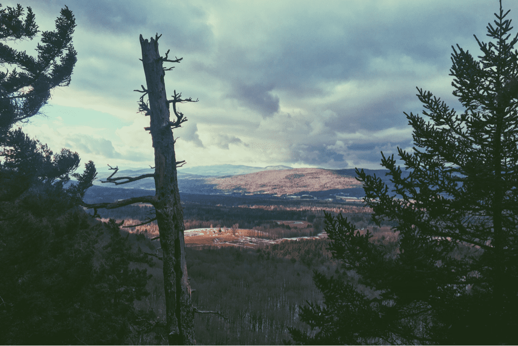
I made phone calls and posted the blog, utilizing the great cell service the ridge provided. We've had bad luck with service at shelters for the past few nights, which we've had to make up for by using our phones as we hike when reception allows for it. Stopping at a vista to photograph the airport and small town of Clarendon, VT in the valley below, we then made a steep and icy descent down through an otherwise barren forest floor. Crossing a narrow pedestrian bridge over the beautiful Clarendon Gorge, we hiked another tenth of a mile before arriving at VT103. Removing our light traction we skipped out on heading directly across the road to continue the LT, instead walking a mile or so on pavement to a small ga station/convenience store/restaurant named Loretta's. There had been a menu left in the shelter the night before and we figured it was worth the road walk for a hot sandwich. We each got chicken parm subs, and as Santa caught up with family on the phone I began calling hotels in Killington to try and book us a room. One lady laughed and asked me if I realized it was a holiday vacation week.... thanks for that. We secured a room at the Long Trail Inn, a half mile off the trail itself, for the steeper price of $240/night, but at this point I don't really care. We've been living in the cold and wet woods for 10 days, I want to take a damn shower.
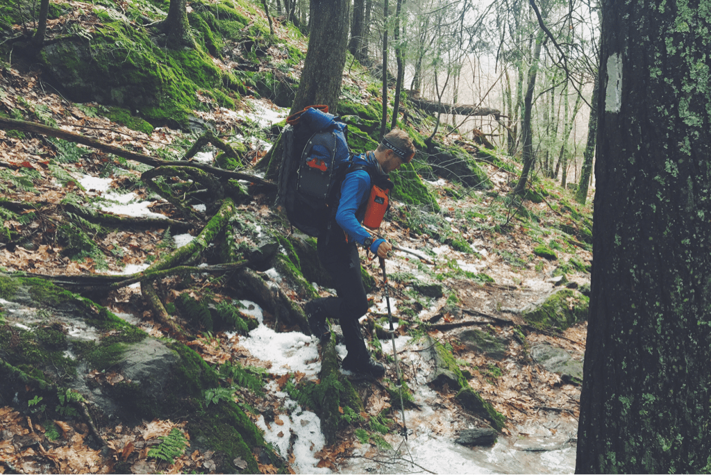
We walked back to the trail and were hiking again by 1100hrs, making a steep and rocky climb out of the roadway gap up to the Clarendon Lookout vista about 500' above. A few quick rises and falls in the trail brought us to the Clarendon shelter where we refilled our water and quickly carried on. With today only being 10 miles of trail, we weren't in a huge rush but stayed focused on the task at hand. Another very steep climb from the shelter brought us to the top of Beacon Hill with an FAA radio tower a top it, our last steep climb of the day. The next five miles would be relatively simple as far as elevation went, meandering over hills and around farmlands, crossing gravel and paved county roads, all the while beginning the ascent to a shelter at the base of Killington where we would spend the night. Despite the terrain not being too difficult, we both struggled with the light snow on the ground. The warm temperatures (mind you when I say warm I mean 45 degrees) had us sweating profusely, our pants and sleeves rolled up to cool us down, but it also made the snow on the ground wet and very heavy. Our light traction was helping but couldn't prevent us from slipping around a bit with each step, so we grew tired and frustrated as the miles seemed to creep by.
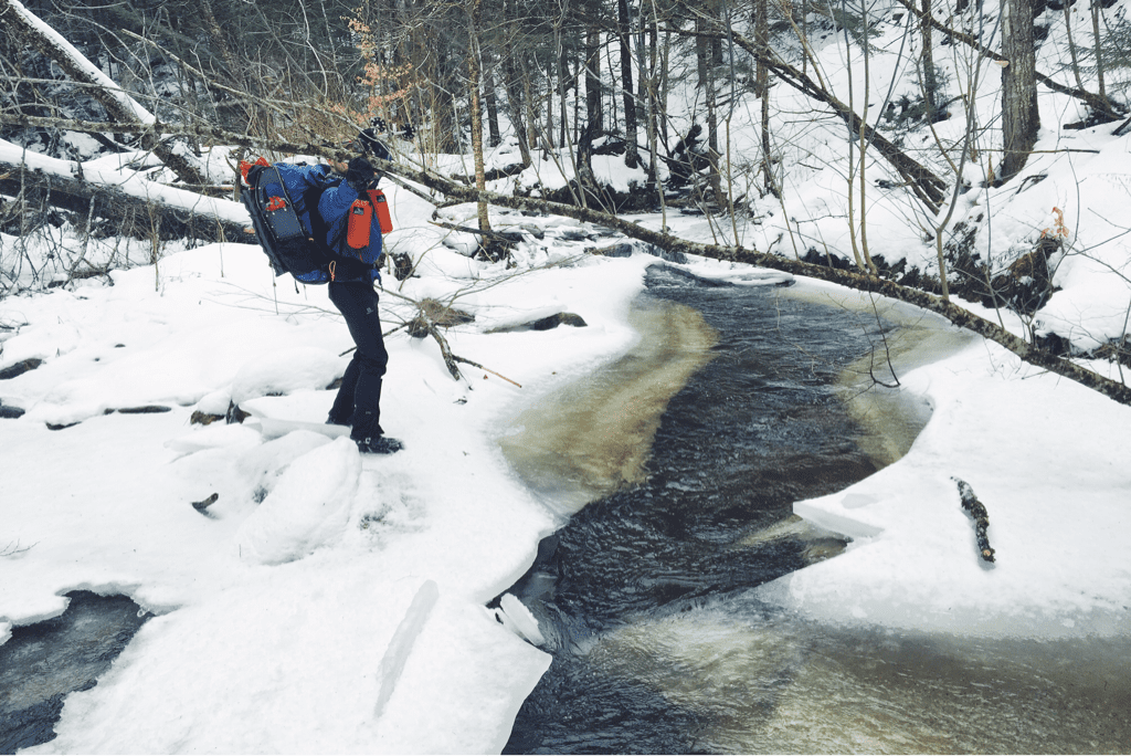
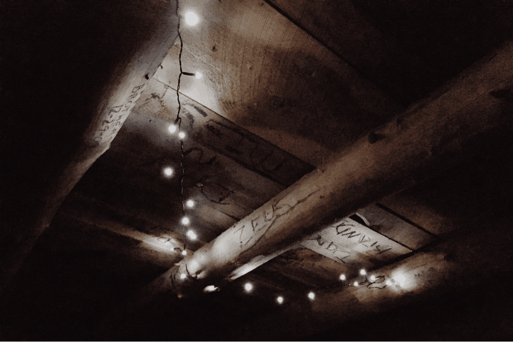
The afternoon presented us with two more dangerous river crossings, water rushing by as a result of the rainfall and the steps between rocks far wider than normal. At one point while crossing a river the piece of ice that I was on, one Santa had just crossed without issue, cracked off and began floating downstream. My immediate reaction was to yell "Iceberg!!" as I jumped to the next sheet of ice in hopes that it would hold me. Our final mile or two crept by as aches in my knees came back for the first time today, likely due to the heft of the snow. We arrived at the Governor Clement shelter around 1545, our earliest arrival yet I believe, and were disappointed to again not have cell service. The old shelter is made of stove and even has a fireplace, and was apparently a popular party hangout for local kids until a few years ago. We set our sleeping gear and cooked dinner under the glow of my LED Christmas lights that I hung from the ceiling.
Falling asleep around 1930hrs, I awoke an hour later to the sound of a truck and opened my eyes to find headlights illuminating the field in front of the shelter. I woke Santa as a second vehicle arrived and we heard car doors slam, he and I preparing for war with our headlamps and heaviest water bottles, but never once moving from the comfort of our sleeping bags. Luckily nobody came into the shelter (I've got no idea where they went or why they stopped actually) and we fell back to sleep.
Tomorrow is another ten mile day up and over Killington Peak, descending as quickly as we climbed down to the road crossing at VT Route 4 where we'll find our hotel. The hope will be to arrive early enough to get our resupply out of the way, eat a large hot meal, wash and dry our stuff (boots are soaked from the warmth today), then sleep well in an environment that isn't subject to sub-freezing temperatures.
Almost 100 miles in. We're exhausted, but we're getting there.
Texaco
Mileage: 9.7 (plus 2 off trail)
Long Trail Mileage: 93.9
Time: 5.5 hours
Day / Night Temp: 45 / 22 F
--
Last night presented a totally different kind of sleeping challenge from the windy and single digit nights we've had before. With temperatures in the mid 30s, well above the -15 degree rating of my sleeping bag, I awoke to find myself sweating profusely in my long sleeve undershirt and long underwear bottoms. I changed to compression shorts as the wind howled and rain continued to soak the forest floor, eventually falling back asleep for the remainder of the night. We awoke at 0700 and packed our gear, eager to have a less challenging and stressful mileage day ahead of us. Departing from the shelter at 0830 or so we climbed out sharply up another 200' to the top of a ridge that we would meander along for the better part of two miles.
I made phone calls and posted the blog, utilizing the great cell service the ridge provided. We've had bad luck with service at shelters for the past few nights, which we've had to make up for by using our phones as we hike when reception allows for it. Stopping at a vista to photograph the airport and small town of Clarendon, VT in the valley below, we then made a steep and icy descent down through an otherwise barren forest floor. Crossing a narrow pedestrian bridge over the beautiful Clarendon Gorge, we hiked another tenth of a mile before arriving at VT103. Removing our light traction we skipped out on heading directly across the road to continue the LT, instead walking a mile or so on pavement to a small ga station/convenience store/restaurant named Loretta's. There had been a menu left in the shelter the night before and we figured it was worth the road walk for a hot sandwich. We each got chicken parm subs, and as Santa caught up with family on the phone I began calling hotels in Killington to try and book us a room. One lady laughed and asked me if I realized it was a holiday vacation week.... thanks for that. We secured a room at the Long Trail Inn, a half mile off the trail itself, for the steeper price of $240/night, but at this point I don't really care. We've been living in the cold and wet woods for 10 days, I want to take a damn shower.
We walked back to the trail and were hiking again by 1100hrs, making a steep and rocky climb out of the roadway gap up to the Clarendon Lookout vista about 500' above. A few quick rises and falls in the trail brought us to the Clarendon shelter where we refilled our water and quickly carried on. With today only being 10 miles of trail, we weren't in a huge rush but stayed focused on the task at hand. Another very steep climb from the shelter brought us to the top of Beacon Hill with an FAA radio tower a top it, our last steep climb of the day. The next five miles would be relatively simple as far as elevation went, meandering over hills and around farmlands, crossing gravel and paved county roads, all the while beginning the ascent to a shelter at the base of Killington where we would spend the night. Despite the terrain not being too difficult, we both struggled with the light snow on the ground. The warm temperatures (mind you when I say warm I mean 45 degrees) had us sweating profusely, our pants and sleeves rolled up to cool us down, but it also made the snow on the ground wet and very heavy. Our light traction was helping but couldn't prevent us from slipping around a bit with each step, so we grew tired and frustrated as the miles seemed to creep by.
The afternoon presented us with two more dangerous river crossings, water rushing by as a result of the rainfall and the steps between rocks far wider than normal. At one point while crossing a river the piece of ice that I was on, one Santa had just crossed without issue, cracked off and began floating downstream. My immediate reaction was to yell "Iceberg!!" as I jumped to the next sheet of ice in hopes that it would hold me. Our final mile or two crept by as aches in my knees came back for the first time today, likely due to the heft of the snow. We arrived at the Governor Clement shelter around 1545, our earliest arrival yet I believe, and were disappointed to again not have cell service. The old shelter is made of stove and even has a fireplace, and was apparently a popular party hangout for local kids until a few years ago. We set our sleeping gear and cooked dinner under the glow of my LED Christmas lights that I hung from the ceiling.
Falling asleep around 1930hrs, I awoke an hour later to the sound of a truck and opened my eyes to find headlights illuminating the field in front of the shelter. I woke Santa as a second vehicle arrived and we heard car doors slam, he and I preparing for war with our headlamps and heaviest water bottles, but never once moving from the comfort of our sleeping bags. Luckily nobody came into the shelter (I've got no idea where they went or why they stopped actually) and we fell back to sleep.
Tomorrow is another ten mile day up and over Killington Peak, descending as quickly as we climbed down to the road crossing at VT Route 4 where we'll find our hotel. The hope will be to arrive early enough to get our resupply out of the way, eat a large hot meal, wash and dry our stuff (boots are soaked from the warmth today), then sleep well in an environment that isn't subject to sub-freezing temperatures.
Almost 100 miles in. We're exhausted, but we're getting there.
Texaco


 RSS Feed
